|
|
| << PREV |
|
|
Slowness has really nothing to do with the
question. An event is not any more intrinsically
intelligible or unintelligible because of the pace
at which it moves. For a man who does not
believe in a miracle, a slow miracle would be just
as incredible as a swift one.
G. K. CHESTERTON
(1925, 21)
Charles Lyell visited Niagara Falls in October 1841 (K. Lyell 1881,
2:58).[1] Quite possibly
as he traveled in the horse-drawn coach over the Canadian roads of the
day, he recalled one of his earliest childhood memories that had been vividly
fixed in his mind at the age of four. The event took place while his family
was traveling in two coaches from Scotland to their new home in England.
A short distance from Edinburgh on the narrow road with a steep hill on
one side and a sharp drop on the other, the horses pulling the first coach
were frightened and took off at a gallop. The coach overturned; there was
a broken window though nothing more serious, and the party was on its way
again (K. Lyell 1881, 1:2). The event made a lasting impression on Lyell's
mind, which some have suggested was the cause of his particular aversion
to catastrophes. This may neatly fit into classical psychoanalytic theory,
but the only fact we can be sure about is that Lyell attempted to explain
every natural rock formation in terms of the very low rates at which we
see changes taking place today -- rivers changing their course, cliffs
being eroded by the waves of the sea, and then, during his visit to Niagara,
the rate of recession of the falls (K. Lyell 1881, 2:60).[2]
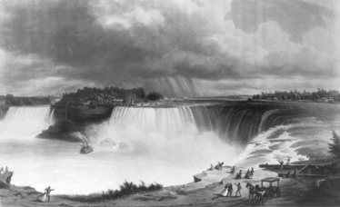
Niagara Falls at about the time of Lyell's visit. Table rock in the foreground and the lighthouse on the opposite side of the Falls have long since disappeared. (Lithograph by F. Salathé after a painting by H.V. Sebron, 1852; Public Archives of Canada, C-2266) |
The Niagara River originally poured over the rim of the Niagara Escarpment just above the present village of Queenston, Ontario, carrying the waters of Lake Erie from south to north and emptying into Lake Ontario. Gradually the waters tumbling over the escarpment eroded a channel into the bedrock to form a gorge that moved the falls in a southern direction closer to Lake Erie. The present-day Niagara Falls and the seven-mile gorge are thus part of a long-continuing process. Lyell's purpose in visiting this famous landmark was to determine, if possible, how long ago the Niagara River waters began falling over the escarpment. |
Lyell talked to a local inhabitant and was told that the falls retreat about three feet a year. He assumed that this was an exaggerated claim and concluded that one foot a year would be a more likely figure (Lyell 1867, 1:361). On the basis of this guess, it was then a simple matter to equate 35,000 feet, or seven miles, as 35,000 years that the falls had taken to cut the gorge from the escarpment to the place it occupied in the year of his visit, which is how he arrived at the figure that he announced to the scientific world.[3] The principle was sound enough, but his method can hardly be called scientific or even honest (Bailey 1962, 149).[4]
In recent years the estimate has been revised downward, but in the mid-nineteenth
century it had a most significant impact on the common man's beliefs. Lyell's
Principles
of Geology, as already mentioned, was published in 1830-33, and although
it was met with opposition at first, it eventually became the standard
work on the subject for the next fifty years, running to twelve editions.
Charles Lyell became Sir Charles in 1848, principally because of his Scottish
land-holdings. To the Victorian mind, this title gave his name and books
tremendous credibility and authority; in a similar way today, the news
media seek out a scientist with a legitimate Ph.D. when they want an authoritative
scientific opinion. Lyell's figure of 35,000 years for the cutting of the
Niagara gorge was thus accepted as an actual measurement made by a gentleman
of integrity and quite beyond dispute. For the next few generations this
estimate served wonderfully to demolish any credence in Archbishop Ussher's
date of creation and made the attempt to finish once and for all the orthodox
belief in the Genesis Flood, which was alleged to have occurred a mere
four-and-half thousand years ago.
| Measurement of the rate of recession of Niagara Falls has been
made periodicially since 1841, the date of Lyell's visit, and these published
figures show that, far from exaggerating, the local inhabitant was too
conservative. A rate of four or five feet a year is closer to the facts
(Tovell 1979, 16).[5]
Assuming as Lyell did that the rate of recession had always been the same,
this measured value reduces the age of the falls to between seven and nine
thousand years. Had it been honestly reported in the first place, this
would have been regarded not as a refutation but rather a near confirmation
of the Genesis Flood!
Today's geologist prefers to adopt a cautious figure of twelve thousand years, made on the basis of radiometric tests carried out on some pieces of buried wood discovered in the blocked St. David's gorge, which was part of the original Niagara spillway (Tovell 1979, 17). However, the blocked gorge of Niagara is a story beyond the present purposes, which are to illustrate how a preconception in the mind of one man, Charles Lyell, contributed significantly to the subsequent complete change of mankind's worldview. |
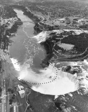
Niagara Falls today showing part of the seven mile gorge that has, until recently, been cut at a rate of four or five feet a year. Dotted lines show position of Falls at time of Lyell's visit in 1841. (Ontario Ministry of Tourism and Recreation) |
Lyell's View of the Earth
Lyell's concept of uniformity had four components. First, he quite reasonably assumed that the natural laws are constant. Scientific inquiry of any kind is impossible if we cannot assume that, for example, the laws holding the planets in orbit or the laws of chemical affinity have not been constant. Implicit in this assumption is the belief that God has never at any time violated those laws by intervention. Second, Lyell assumed that the earth's geological features were caused entirely by processes we see taking place today. Again, this is reasonable but excludes the possibility of large-scale catastrophic events, whether or not they were divinely originated. Third, he assumed that the geological changes are always slow, gradual, and steady; modern geology, however, has conceded that this assumption is too rigid and that some catastrophes have occurred but have been relatively small, local events. Fourth, although Lyell could not accept until quite late in life that species could gradually change from one to another, he proposed that the fossil record represented but one part of a "great year" or grand cycle, where the ichthyosaur and pterodactyl might return once more to inhabit the earth.
In spite of all its sophisticated equipment and techniques, modern geological
interpretation is firmly founded on Lyell's first two uniformity assumptions,
has modified the third, and has rejected and graciously forgotten the fourth.
In addition, since Darwin's day the assumption has been added that life
evolved from the simple to the complex, from the single cell to man, and
that the remains of the various life forms have been buried in the sediments
of lakes and seas and preserved as fossils. It is worth noting that the
Lyellian term "sedimentary" is applied to the most important class of rocks
found throughout the earth and derives from his belief that they all originated
as sediment slowly deposited from bodies of water but occasionally deposited
by wind and ice. In the last two decades, however, it is being cautiously
conceded that at least some sedimentary rocks originated by an entirely
different mechanism (Ronov 1959).[6]
It has been observed that volcanic eruptions can very quickly dump millions
of tons of ash, distinct from lava, either on open ground, such as the
Mount St. Helen's disaster, or underwater, producing a cement-like sediment
trapping life within it in a matter of hours rather than centuries (Kennet
and Thunell 1975; Worzel 1959).[7]
Indeed, the volcano as the agent of destruction of life and subsequent
preservation of the forms as fossils was suggested as early as 1841 by
Hugh Miller, who wrote concerning millions of fossilized fish: "The thought
has often struck me that calcined lime, cast out as ashes from some distant
crater, and carried by the wind, might have been the cause of the wide-spread
destruction to which the organs testify" (Miller 1841, 236). Whatever mechanism
was responsible, the fossils and the sedimentary rocks in which they are
formed are key elements in the whole chain of nineteenth century Lyellian
and Darwinian reasoning.
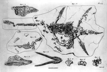
Fossil creatures are often found broken and with parts missing. This example from the atlas to Cuvier's Recherches is typical and shows the Plesiosaurus or sea-dwelling dinosaur (1836 edition, plate 259; Sigmund Samuel Library, University of Toronto) |
About Fossils
Fossils occasionally make the news, especially if they happen to be human, and inquiry will often show that they become the focal point of academic controversy, but the public is seldom made aware of just what passions are aroused by those with a personal or vested interest and with reputations at stake. However, the controversies do not attract the public interest as they did in the middle to late nineteenth century when the battle for evolution was being fought. Even composer Camile Saint-Saëns was captivated by this issue and included the fossils, following the lions and the elephants, in his popular "Carnival of the Animals", written in 1886. |
| Fossils are the remains of once living things: perhaps part of a plant, insect, fish, bird, mammal, or, in very rare instances, the bones of man. Usually it is only the hard, boney parts that are preserved. More often than not, however, much of the skeleton will be missing so that the complete assemblies, especially of large animals, that we see on display in museums are usually the composite result of fossil bones from different sources. In instances where they are found, human remains are often unique, and the museum display will invariably be a plaster copy of the original. |

The Plesiosaurus reconstructed from fossil remains in a painting prepared for the Museum of Natural History, Stuttgart, by Fraas. The original work was destroyed in 1943 and has been restored in this drawing by Mary Wardlaw. |
Almost everyone is familiar with the skeletal remains of dinosaurs,
which generally take pride of place in any museum. On occasion it is possible
for a visitor to acquire a little more information about these huge fossil
bones by touching them: they are stone rather than bone and, of course,
very heavy. The question arises how did a carbon compound, which is the
essential component of bone, change into a silicon compound -- the "mineralized"
component -- and still retain not only the same outward appearance but
the same internal structure and, in the case of fossilized wood, even the
same color? The truthful answer is that since the mineralization process
has never been duplicated in the laboratory, no one can be absolutely sure
of the exact mechanism; the explanations proposed are largely speculative,
all making the assumption that vast lengths of time were involved.
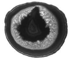
Polished section through an egg-shaped agate stone. The layers of silica appear as concentric rings, each being made visible by varying impurities producing slightly different colors. Entry and exit channels for the water were not evident in this four-inch long sample. |
The common textbook explanation for the mineralization process is that mineral-containing water has seeped into interstices in the fossil, dissolving the bone and at the same time depositing the silica-based minerals from the water -- a molecule-by-molecule replacement process (Schuchert and Dunbar 1950, 38). This may sound plausible, but a moment's consideration shows what any physical chemist knows: such a process is self-stifling; once even the thinnest silica film has been formed, this glass-like material prevents further diffusion of both the mineral-containing water inwards or the dissolved carbonaceous material outwards. The problem is seen most clearly in the case of agates. These egg-shaped stones are formed, it is believed, by deposition of silica from ground water seeping into gas cavities in volcanic lava. The theory requires that the "egg" grows in concentric layers beginning at the outside and finishing at the centre. However, to quote Webster, an authority on gem stones, "It is the absence of the feeding canals in many agates that the main objection to the theory lies" (Webster 1970, 183). Plainly, the fossilization process is still a mystery. |
When an animal dies or is killed, the body very quickly decomposes; bacterial action and scavengers are all part of nature's economy. If this were not so, we would find ourselves stumbling about in dead bodies hundreds of feet deep. Rapid burial to exclude bacteria and scavengers, then, is one of the first requirements of the fossilization process. As Lyell observed, sediment forms at the bottoms of lakes and the ocean, and it is said that for the fossils to be found in sedimentary rocks, they must have fallen to the bottom and been covered over with sediment in some unexplained, rapid way. This is the textbook explanation; the authors then typically point out that such events were likely to be rare, but the vast number of fossils found are explained by the millions of years available to accumulate these numbers.
Exploration of the ocean bed has been carried out since 1872 when the
British ship HMS Challenger took part in a four-year scientific expedition
(Murray 1880-95).[8]
The depth of sediment as determined seismographically in a more recent
expedition varied from none at all to more than thirteen thousand feet,[9]
while the samples examined contained only the countless millions of tiny
shells of the single-celled protozoa such as the microscopic radiolaria
and the foraminifera (Pettersson 1950, 44). Occasionally, sets of shark's
teeth are found, since these are virtually insoluble in sea water, but
the ocean bottom is never found littered with dead bodies waiting to be
fossilized.
Museum Displays
When we see the rather spectacular fossil finds on display in museums,
we might wonder how it was that not only have the bones been preserved
but in many cases they are all in place; there are clear impressions of
the skin, muscles, and even feathers in a few bird specimens. Delicate
bat wings and insects have even been preserved as impressions (Brues 1951,
56).[10] We know,
for instance, that dinosaurs were not covered with hair but had reptile-like
skin, because on occasion impressions of their skin have been left in the
sedimentary rock. We also know that at least certain types of dinosaurs
laid eggs, because clutches of fossilized eggs have been found and the
fossilized embryo is seen inside (Andrews 1926, 229-31).[11]
Presumably, dinosaurs did not lay their eggs under water. It is conjectured
that it was probably windblown sand that caused the rapid burial, but this
same explanation has to serve for the dinosaurs as well since these were
found in the same area. The Stuttgart Museum of Natural History in Germany
contains a fossilized ichthyosaur,
or sea-dwelling dinosaur, fossilized
at the moment of feeding her young. In the Ludwigsburg Museum of Natural
History in Germany, there is an even more spectacular specimen of an ichthyosaur
fossilized
in the process of giving birth with the young clearly visible in the birth
canal. In the Princeton Museum of Natural History there is a perch fossilized
in the act of swallowing a herring. In each of these examples, the creatures
were sea-dwelling, and their burial under fine sediment and subsequent
fossilization had to have been sufficiently rapid to leave no trace of
decomposition.
Fossil Evidence of Catastrophe
In England, one of the largest sedimentary rock deposits covering thousands
of square miles is known as the Old Red Sandstone, and it contains many
millions of fossilized fish in contorted positions indicating that they
died in agony (Chambers 1887, 56; Miller 1841, 232).[12]
In some of the Sandstone quarries the fossil fish are so densely packed
it is estimated there are more than a thousand per cubic yard. There is
a similar sedimentary rock deposit extending for hundreds of square miles
on the California coast and containing millions of fossil herring; again,
all appear to have died in paroxysms of agony. The famous fossil bird,
Archaeopteryx,
found
in the Solnhofen Limestone, east of Stuttgart, Germany, and which appears
in most school biology textbooks, died with its neck contorted backwards.
In the Drumheller fossil beds of Alberta, there are millions of fossil
clams in a layer three feet thick and packed together with each pair of
shells tightly closed. Normally, clams do not live packed together, and
when a clam dies, the muscle holding the shells in a closed position relaxes,
and the shells spring open. This fossil evidence indicates that these clams
were buried alive; a similar fossil bed is found in Texas. These few examples,
which are by no means isolated, can all be better explained in terms of
a massive catastrophe in which deep ocean sediments were suddenly brought
up, entrapping sea life, then encroaching the lowlands and drowning and
entombing dinosaurs with their eggs. If the evidence seems to support a
massive disturbance in the oceans, what evidence is there that the ocean
waters swept inland covering even high ground?
| In the suburbs of Los Angeles may be found the well-known asphalt pit of Rancho La Brea, where thousands of animal bones mixed with clay and sand are found in the bituminous deposit; the black tarry substance has beautifully preserved the bones. The site began to be "mined" for asphalt for roofing and paving in San Francisco more than a century ago, and the bones were reported at that time. Since 1906 the University of California has been collecting these fossil skeletons, which are crowded together, and, for the most part, disassembled. The best known animal skeleton found at La Brea is the saber-toothed tiger (Smilodon), having curved canine teeth more than ten inches long and, fortunately, now extinct. Many of the world's museums display this fierce creature with the original fossil material since hundreds of saber-toothed tiger skulls have been recovered (Page 1983).[13] A great many other animals are recognized among the La Brea fossil remains including wolves (three-thousand individuals), bison, mammoths, camels, horses, some birds, and the separated bones of a human skeleton, the skull of which was said to be no different from the human skull of today (Boule and Vallois 1957, 478).[14] This last item is not an isolated case; the jawbone of a young child was recently found by Irving in an animal graveyard in the permafrost of the Yukon Territories (Irving and Harington 1973).[15] |
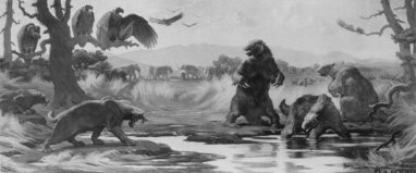
The Rancho La Brea tar pits according to the textbook interpretation and conceived in this painting by Charles R. Knight for the American Museum of Natural History. (American Museum of Natural History, New York) |
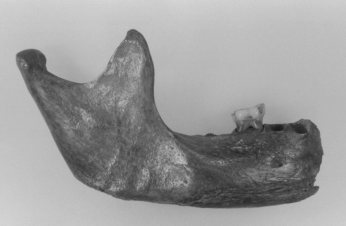
Jaw-bone of a child eleven or twelve years old, discovered in an animal graveyard in the Yukon in 1976. The investigators are hesitant to attach an age to it. (B. F. Beebe, University of Toronto) |
The usual explanation given in geology textbooks and in the popular
Time-Life books for these masses of animal bones at La Brea (there are
a similar bituminous deposits in Peru and in Poland) is as follows:
Throughout the ages the volatile parts of the escaping oil have evaporated, leaving behind the sticky residue of asphaltum, which formed a death trap for the prehistoric animals of southern California. Animals coming to the seeps for water, or attempting to cross soil-covered patches of asphalt, were trapped ... their death cries attracted carnivores and scavengers which in turn became engulfed. Their bones lie beautifully preserved -- although all in a jumble -- in the asphalt deposits, from which they have been recovered by the hundreds of thousands (Schuchert and Dunbar 1950, 44). |
This is typical of the explanation usually given, while what the public normally sees are nicely reconstructed skeletons or imaginative reconstructions, such as the painting by Charles R. Knight in the American Museum of Natural History in New York. This sort of explanation might be satisfying were it not for further facts that somehow are seldom commented on by textbook authors. Lull, for example, mentions that "the asphalt tends to work so that the bones are pulled apart and one never finds a skeleton in articulation [connected together]" (Lull 1935, 28). This is pure speculation since there is no evidence that the asphalt is in a state of motion and, in any case, this would not explain the disconnected bones found mashed together at other locations where there is no asphalt. The disconnected skeletons and broken bones are more easily explained by a catastrophe, such as turbulent flood waters of tidal dimensions sweeping up fleeing animals in their path and dashing bodies against rocky ravines and gorges. Possibly, at La Brea, there was an oil seepage that subsequently permeated the smashed remains; this is speculation, but it would better satisfy the facts than the conventional textbook explanation.
Typical of a fossil grave site not associated with asphalt is the Agate
Spring Quarry, Nebraska, which contains a fossil-bearing deposit up to
twenty inches thick and containing as many as one hundred bones per square
foot. Thousands of animals are represented at this site, most of which
are extinct; again, the skeletons are disconnected and the bones smashed
and broken, all of which indicates that the animals were caught up in a
violent cataract of water, sand, and gravel and driven into the common
grave in which they are found today.
Sinking Continents
Although it might be possible that all this evidence could
be the result of violent but local floods, there is also the type of evidence
that Lyell used to support his contention that the continents have sunk
beneath the ocean waters and risen again. Fossil sea shells and marine
creatures are found in the tops of hills and mountains throughout the world.
In several places fossil whales have even been found in hilltops, and Laverdière
(1950) has reported examples in the Montreal-Quebec City area where a fossil
whale was found in the Laurentide Hills at more than five hundred feet
above sea level.[16]
Whether the land sank beneath sea level here, as Lyell maintained, or the
sea level rose above the land, the result would be the same -- a flood.
| Plainly, evidence is provided of vertical and upward movement on a massive scale by the upturned sedimentary rocks containing marine fossils in mountain ranges. There is, however, less spectacular evidence of vertical movement but no indication of the direction, that is, whether up or down, in the raised beaches that are often found to be tilted from the horizontal along their length. One such tilted beach runs the complete length of the north shore of Lake Ontario and is seen as prime evidence that the entire continent sank beneath the present sea level and then reemerged but not quite uniformly. It is assumed that the weight of the ice during the ice age was the cause of the downward movement of the continent, but then this Lyellian argument also requires vertical movement for large areas such as Arizona, where it is acknowledged that there was no ice. Furthermore, repeated inundations are often called for to account for the various sedimentary layers, but no one really knows the mechanism by which whole continents are said to have sunk then risen again (Hallam 1963).[17] |
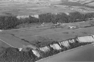
Raised beach runs around the north shore of Lake Ontario and is tilted from end to end indicating some vertical movement of the land. First beach hidden by trees across the center of the photograph; today's beach in the foreground. (Photo by D. Cox) |
In point of fact, in a raised beach the only hard evidence for vertical
movement is the difference in elevation between the highest and lowest
parts of the beach; nothing can be said about which end went down and/or
which end went up. Further, it is really going beyond the limits of the
evidence to claim that the entire continent sank hundreds of feet, which
is what would be necessary to bring it all beneath the present sea level,
on the basis of the relatively short distance evidenced by the raised beaches.
So whether we would believe that the entire continent sank or the present
sea level rose to provide the flood as witnessed by the marine fossils,
scientists acknowledge the difficulty of finding the mechanism responsible
for the vertical movement of either the land in the one case or the sea
in the other.
Back to Niagara Falls
The discovery of the fossil whale near Montreal brings us full circle
back to Niagara Falls, since these two locations are roughly in the same
geographical area. Lyell's followers have maintained that this area of
Canada sank below sea level under the great weight of the ice during the
last ice age; ice assumed to be several miles thick is required by the
argument in order to cause the land to sink, and it was further assumed
that the land remained submerged for some time after the retreat of the
ice. This extended period of submersion is necessary in order to account
for marine fossils such as the whale; it is reasonably assumed that the
creature was not carried by the ice, neither did it walk over dry land.
Having the Laurentide Hills beneath sea level somewhat less than thirty-five
thousand years ago, according to Lyell's estimate for the last ice age,
is perhaps sufficiently remote in time to be believable. However, now that
the estimates for the cutting of the Niagara gorge and the last ice age
have been reduced to twelve thousand years, while the measured rates indicate
seven to nine thousand years, that is asking us to believe that the Laurentide
Hills only rose from beneath the sea some five or six thousand years ago.
At this point it is almost possible to believe that it was the Genesis
Flood that left the area four-and-a-half thousand years ago!
What About the Ice Age?
Professor Louis Agassiz's monumental Études sur les Glaciers [The Study of Glaciers] appeared in 1840, barely two years after Lyell's Elements of Geology. Agassiz was born in Switzerland and, during Swiss mountain hikes, he noticed that as the glaciers moved down the mountain valleys, the stones and rocks carried within the ice scratched the underlying bedrock. This left score marks parallel to the direction of the ice flow. He further noticed that as the glaciers retreated they left in their wake the rocks and stones they had carried. In 1856 Agassiz arrived as an immigrant to America and here he noticed these same indications of ice flow and reasonably concluded that, like the northern parts of Europe, North America had also experienced an ice age. After reading Agassiz's work Charles Lyell believed he had found the mechanism for the elevation and submergence of continents. He theorized that just as high mountains become ice-covered, so too might entire continents if they had become sufficiently elevated by subterranean volcanic action. He proposed that by the accumulation of enough ice, say two miles thick, this would depress the elevated continents below sea level. Here the ice would eventually melt allowing the submerged land to receive the sediments. Later, helped by the mysterious process of "isostasy," the continents would elevate once again above sea level. Of course, since there were twenty-one sedimentary layers of rock this entire process would have been repeated the same number of times. Lyell's explanation was eagerly welcomed by anti-biblical enthusiasts, and, while they were reluctant to argue for twenty-one ice ages, the textbooks settled for four. In 1863 Lyell made tentative suggestions in this direction in chapters 12 to 16 of his Antiquity of Man. There have been half a dozen theories to explain the origin and the number of ice ages. It is perhaps in recognition of this that textbooks today speak of "interglacial periods" thus not having to commit themselves to any specific number.
Agassiz died in 1873, Lyell followed him two years later and it was now an opportune time for opponents of Lyell's ice age theory to express their own ideas. In 1893 Sir Henry Howorth, a catastrophist, published The Glacial Nightmare and the Flood. In this work he showed that the concept of uniformitarianism and the evidences for a world-wide flood were irreconcilable. More recently, climatologist Michael Oard (1990) has pointed out that an ice age requires two simultaneous and opposing conditions: The ocean temperatures must be slightly higher in order to increase the rate of evaporation and thus provide moisture for the extended snowfall. At the same time, the temperature of the continental land mass must be lower in order to retain the snowfall year after year. These are unique conditions only likely to have happened once in earth's history and make no appeal to rising and falling continents. From the biblical description of the Genesis flood, the "fountains of the great deep" (juvenal water beneath the crust) warmed the oceans and flooded the land. At the same time, the associated volcanic action filled the upper atmosphere with dust and reduced the temperature of the continental land mass for years. However, Lyell's followers dismissed the work of Howorth just as they would that of Oard today and for the same reason.
In the late 1800's the astronomical theory claimed that the eccentricity
of the earth's orbit about the sun produced a long-term cycle of heating
and cooling. This theory could explain any number of ice ages. While warmly
welcomed at first, it was eventually dismissed because there were too many
problems. Then, in the 1970s, some unrelated work reported the distribution
of the oxygen isotope 18 in planktonic shells brought up in sea-bed core
samples. The values seemed to vary cyclically indicating a rise and fall
in the temperature of ancient seas. The atmospheric theory, now called
the Milankovitch theory, was quickly revived and Lyell today would be happy
to see twenty to thirty ice ages being explained away by it. However, there
are in fact, enormous problems with both the astronomical theory and the
oxygen 18 analysis while the cause of any ice age remains to this day,
a complete enigma. Adding to the mystery of the ice age are the evidences
that the earth's polar regions were much more hospitable than they are
today. During his Antarctic expedition of 1907-9, Shackelton (1909, 2:314)
discovered seven seams of coal, each between three and seven feet thick.
[18] In the Arctic regions
warm-water coral has been discovered virtually beneath the North Pole.
Canada's Axel Heiberg Island is the nearest land to the watery pole and
has become well known for its frozen forest of metasequoia trees,
some three feet in diameter. On neighboring Ellesmere Island were found
the remains of subtropical animals including alligators, crocodiles and
giant land tortoises (Christie and McMillan 1991). In the meantime, there
is still no convincing evidence or mechanism for the rising and sinking
of continents or for multiple rising and falling of sea levels.
| Frozen Mammoths
Ever since the late 1700s when men began to return with travelers' tales of some of the more remote parts of the earth, there have been intriguing accounts of animals buried and preserved whole in the frozen wastes of northern Siberia and Alaska. Unlike the other fossil graveyards where only broken bones are found in confusion, the vast cemetery of the north teems with complete animals, wolves, bears, elephants, rhinoceroses, and the woolly mammoths with their beautiful tusks of ivory (Whitley 1910).[19] There are many of these animals preserved with their bones fresh and not at all mineralized, and, since Roman times, ivory "mining" has been a steady and lucrative trade (Farrand 1961; Lippman 1962).[20] The Chinese, renowned for their ivory carving, use mammoth tusks from Siberia, and it is estimated that northern Siberia has provided more than half the world's ivory for such items as billiard balls and piano keys. While Darwin played his game of billiards or listened to his wife play the piano, the ivories involved may well have come from the Siberian mammoths whose extinction he admitted was an insoluble problem to Lyell's principle of gradual changes and his own theory of evolution (Colp 1977, 65; Whitley 1910, 56).[21] |
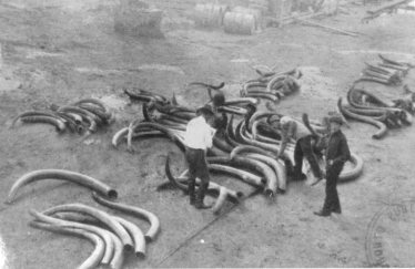
Sorting mammoth tusks at an ivory auction yard in Siberia about 1920. Ivory mining has been continuous since Roman days and surely represents many thousands of buried mammoths. (Metropolitan Toronto Reference Library Board) |
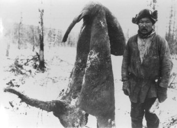
The erect genital of the Beresovka mammoth is an indication that the creature died of suffocation (frozen lungs?). It appears in the bottom left of the photograph while the tail is above. The connecting strip of hide has been turned through 180 degrees for the photograph. (Smithsonian Inst., photograph number 83-2243) |
The year 1901 provided a unique opportunity to make a first-hand scientific study of a mammoth that had then recently been exposed on the banks of the Beresovka River in northeastern Siberia and sixty miles inside the Arctic Circle (Digby 1926; Billow 1981; Pfizenmayer 1939; Sanderson 1960).[22] The mammoth was found frozen in a sitting position in what is technically referred to as muck and located in the middle of an ancient landslide. The flesh and even the eyeballs were so well preserved that the expedition's sled dogs had plenty of fresh meat to eat. Death must have come to this specimen very quickly, because the blood still contained some oxygen and was preserved sufficiently well to establish the relationship to the blood of today's Indian elephant, although distinct anatomical differences would not necessarily classify them as the same species. There was well-preserved food in the mouth and twenty-four pounds of undissolved and identifiable plants in the stomach. One interesting and unexpected feature reported by Herz (1904, 623) was an erect male genital.[23] Now all these details were soberly reported in the scientific journals of the day, including the annual report of the Smithsonian Institution for 1903, yet geology textbooks still insist on the uniformitarian explanation that the unfortunate creature -- as if it were the only one -- must have stumbled and died where it fell amid the snow-covered wasteland. |
Imaginative paintings of the wooly mammoth by artists such as Burian have traditionally shown these animals in a winter landscape. Yet the reported examination of the skin showed that the creature had no sebaceous glands and therefore could not have oiled its fur to survive in Arctic conditions. Further, more than fifty varieties of herbs, grasses and mosses, some of which only grow in temperate climates, were identified in the stomach (Dillow 1981, 371-80). The buttercups, for example, were in seed and fixed the time of death in late July or early August.
All these and many more details of the mammoth have been available in English to anyone willing to make inquiry at even a modest university library. Yet for most who actually do so and who popularize the mammoth mystery, there is the natural tendency to develop a theory to explain the mystery. Unfortunately, details that do not fit the particular theory often go unreported. Since 1981, Joseph Dillow's The Waters Above has provided a popular explanation for the Beresovka Mammoth. His explanation relies upon a catastrophic drop in atmospheric temperature causing the creature to literally freeze in its tracks. The evidence cited for this is the preserved remains of the delicate sedges and grasses found in the stomach. However, unknown to Dillow was the fact that, like the elephant, the mammoth had two stomachs; the first was simply a holding vessel while the second was for the actual digestion. The scientists who had examined the Beresovka mammoth reported the contents of the first stomach. Prior to Dillow's work there were others who had drawn a similar conclusion based upon the erroneous understanding that the mammoth contained only a single stomach. Their theory proposed that the earth had passed through the icy tail of a comet. The ice particles at the temperature of outer space were caught up in the earth's gravitational and magnetic fields and dumped on the magnetic north and south poles (Gow 1972; Patten 1976; Sears 1979).[25 ] It was argued that there could have subsequently been some glaciation at the edges of the instantly formed ice field. The ice-dump theory was claimed to account for Canada's permafrost, ice caves between lava rocks (Patten 1976, 120), and the Ross sea-bed core evidence that indicates that Antarctica only became ice-covered as recently as six thousand years ago (Hough 1950).[26] The bottom line is that thousands of these mammoths had lived in the Arctic when the climate was moderate and there was sufficient food. There was an Ice-Age in which most of the mammoths died and decayed and a very few remained frozen. Beyond that no one knows exactly what or how it happened.
Contrary to popular impression the Ice Age produced cooler summers and
milder winters than is presently the case. Moreover, large regions of Alaska
and the Beringia area of Siberia were not glaciated; it is precisely in
these regions where the mammoth remains are found. Before the Ice Age these
areas must have had more equable conditions with no permafrost and plenty of
vegetation and in order to support these huge animals. The mammoth remains
are mostly
entombed in loess, a wind-blown silt, known in Siberia as yedoma. It is
postulated that the animals were buried by dust storms towards the end
of the Ice Age. Such a death would explain carcasses found in a standing
position and, with death by suffocation, would explain the erect genital
of the Beresovka Mammoth. The oft-quoted preservation of the mammoth
stomach contents are, as mentioned above, more simply explained by the
fact that, like the elephant, the mammoth had two stomachs. Digestion
begins in the second and continues all the way through the caecum and
colon. Oard's theory may well shed some real light on
the mystery of the mammoths.
What Kind of Rock Is That?
For those who have been visitors to the Grand Canyon in Arizona and have stood on the canyon rim with a clear drop into the abyss below, the view is not only breathtaking -- words are really inadequate to describe it -- but there is also a sense of wonder as unanswered questions flood through the mind. Nature has permitted man to see at this unique spot a cross section through about a mile of the earth's crust. The United States Parks Service, fully aware of the visitor's feelings, provides geology lectures at popular spots along the south rim of the canyon; they also post geological explanations beside each type of rock formation on the well-beaten trails to the Colorado River, which winds its way along the very bottom of the canyon. Most spectacular are the various layers of rock quite sharply delineated by color and texture that line the canyon walls. The canyon is really a major fissure or crack across the top of a bulge in the Earth's surface and 200 miles long. By the time the visitor leaves the canyon, his mind is reeling with names such as Kaibab, Toroweap, Permian, Devonian, and Cambrian, while all the millions of years involved are just too staggering to comprehend.
By what divination does the geologist conclude from the examination of a piece of rock its name, its age, and its history in relationship to other rocks in the same area? The situation can be reduced to something relatively simple when it is appreciated that there are basically only three types of rock that may receive names from two sources. The rock types may be igneous, which means that at one time such a rock was hot and liquid -- lava from volcanoes, basalt, and granite are common examples. Or the rock may be sedimentary meaning that it was formed from fine sediment as it settled in water. Sedimentary rock may also be formed from fine wind-borne dust blown from, say, a volcano. Limestone, sandstone, shale, and clay are examples, although the clay is really a sediment at the stage before it has hardened into rock. The third type is called metamorphic rock and may have been either igneous or sedimentary in origin, but in some way, as yet unknown, it has crystallized and become very hard. Marble is thought to be metamorphosed limestone, while anthracite is believed to have come from bituminous coal, which is technically a sedimentary rock. That is not too difficult, and anyone can make a good start at identifying the three types of rock by a visit to a local cemetery.
The names of rock strata come from two sources: First, there is the
local geographical name, such as Kaibab, Toroweap, and Coconino, which
are, for example, names used to identify the various strata at the Grand
Canyon. These same strata will also be catalogued under one of the geological
age names, which is the second source of names for rocks. Geological age
names such as, Cenozoic (era) or Devonian (period), are just that, the
name indicating its assigned age according to
a scheme worked out by Lyell and others in the nineteenth century.
Age Names and the Geologic Column
Before proceeding with a discussion on the geologic column, a common misunderstanding needs to be exposed and dismissed. Readers will recall a full-page illustration that appears in virtually every school biology textbook titled The Geologic Column. Horizontal lines represent the various geological strata neatly labeled with Era, Period and Epoch names adjacent to a column of life forms. Quite often, the ages given in millions of years are included although these numbers have quietly increased from generation to generation as may be seen from the older textbooks. The life forms are arranged in a rising order of complexity showing the trilobite at the bottom then the fishes, amphibians, reptiles, mammals and finally man at the top. The accompanying text tells the reader of the importance of the geologic column and how it is the strongest evidence for the evolution of life on planet Earth. Lacking further explanation the reader would naturally conclude that the Earth's strata containing every fossil of these life forms exist in that very order beneath one's feet regardless of whichever country one happens to be standing. The fact is, nothing could be further from the truth! The illustration is merely an ideal to illustrate a principle that those who write the textbooks wish were true. Fossils of the life forms shown in the illustration are very seldom found to have any resemblance to the order shown and have never been used by the geologist. From the earliest days when the study of rocks was becoming a science, geologists have always used the index fossils to identify and trace individual strata.
Naturalists such as Cuvier and Deshayes, working in Paris a few years before Lyell was born, discovered that strata often contained fossils of shell-bearing marine species such as small mollusks and clams. The uppermost beds contained shells of species that still live today while successively lower groups of strata were found to contain shells of fewer living species and more extinct species. Later, Lyell saw this as a principle and proposed a classification based on the percentage of still-living shelled invertebrates, the clams for example, and coined age names for rocks based upon this arbitrary division. Thus, he said that those rocks containing 50-90 percent of modern species would be called Pliocene, from the Greek meaning "more recent". Rocks containing 20-40 percent of the fossils represented by modern species would be called Miocene, meaning "less recent", while those containing less than 5 percent would be called Eocene, meaning "dawn". The historical background to Lyell's work on index fossils was given in the previous chapter. Lyell had made his proposal in the 1830s, before the rocks of the world had been studied. It has since been discovered that the percentage of living species found in rocks believed to be of the same age varies from region to region and country to country. Thus, index fossils are far from universal and the Australian, British, and the American geologists are obliged to use different lists of these fossils. Nevertheless, like-minded followers of Lyell quickly elaborated on his scheme, subdividing and extending further backwards in time and assigning ages to each geological era. In spite of the deficiency of Lyell's method, certain fossils came to be recognized as typical of each age, while some juggling of the various fossil forms was necessary to fit the assumed upward gradation of complexity into proper chronological sequence; these particular fossils ? the marine crustaceans -- became the "index" fossils for the system. The existence of a particular index fossil found in a rock sample then immediately associates that particular strata with an age name and, of course, with the age that has been assigned to it (Dunbar 1960, 352).
For example, the age name Cambrian, with the subdivisions of upper, middle, and lower, refer to that very early period in Earth's history. These names appended to rock strata, thus depend upon the fossils found in them and have nothing to do with color, texture, chemical composition, or any other characteristic of the rock. For example, a layer of limestone at one point, of chalk at another, and of sandstone at a third might all be called Cretaceous and assigned an age of 130 million years or so if they all happen to contain the same index fossil.
Strictly speaking, the age of rock strata is of no practical importance to the working geologist. This should be self-evident knowing that the assigned ages have increased twenty to thirty times in the past century without making any difference to say, oil or mineral exploration. The ages of the various geological eras were originally derived during the nineteenth century by a combination of guesswork and calculation. For example, by estimating the depth of sediment deposited in one year by a river when in flood and knowing the total depth of sediment by drilling a hole, the age of the river system could be calculated. Often the annual rate was a fraction of an inch, and with a total depth of sediment of hundreds of feet, great ages were assigned to that particular layer of sediment. It was argued that the calculations should be based upon the thickest layer of any given strata discovered because similar strata of lesser thickness would have been the result of erosion. Further, the calculations assumed that the measured deposition rate over one year had been the same throughout Earth's history. The assigned ages, particularly for the earliest forms of life, seem to have been put on a sliding scale that has increased in direct proportion to our understanding of the complexities of the living cell. In Lyell's day, for example, the beginning of life was thought to have occurred about 200 million years ago, but this estimate has since escalated to 3,870 million years, almost twenty times longer. In recent years the claim is sometimes heard that the radiometric methods ( but not the Carbon Fourteen method) provide an independent, foolproof confirmation of the ages ascribed to the strata. However, this is quite untrue as the radiometric themselves are in fact calibrated against the dated strata.
Based upon Lyell's system, the index fossils -- sea shells -- have since been arranged on paper in a vertical column representing every possible strata. The index fossils are all quite small, less than the size of a penny in most cases, and conveniently enables them to be identified in say, a six-inch drill core. Fossils of larger creatures would not be recognized in such a drill core. Although index fossils do appear in a rough order, in practice there often are overlapping zones with two index fossils together; sometimes they appear in reverse order even on a massive geographical scale,[27] while throughout it is always possible to find a fossil totally out of place (Pierce 1957). In the case of fossils of all the other life forms these were long ago arranged in order of complexity with the "simple" trilobite at the bottom and humans at the top. However, deciding what is complex and what is simple is a very subjective exercise. Trilobites for example, although placed at the bottom of the evolutionary ladder, have extremely complex eyes. When fossils of these life forms are found out of place, there tends to be controversy particularly if they happen to be human remains (Corliss 1978).[28]. It seems that scientific literature did contain reports of out-of-place human fossils until about 1859, the time Darwin introduced his theory of evolution. For instance, a human skull was found in a coal bed near Freiberg, Germany, and reported in detail by Karsten in 1842.[28]. At this date, however, Lyell's geologic column was not established dogma and the paper was reported by a reputable scientific journal of the day. A similar finding today, however, would stand very little chance of being published because it would either call into question the whole of geology as a science, or it would have to be concluded, as in the case of the Freiberg skull, that a human being appeared 100 million years before his time! This particular fossil was later found to be a carving using coal as the medium. [29].
The order of the geological age names is, therefore, the supposed order of a set of index fossils based on the assumed order of the evolution of life. At the same time, evidence for the evolution of life is said to be seen by the order of the index fossils. This is circular reasoning and should not be claimed to be science. For some years now an increasing number of reputable geologists have begun to realize this and question the whole principle. Writing in the American Journal of Science, O'Rourke has stated: "The intelligent layman has long suspected circular reasoning in the use of rocks to date fossils and fossils to date rocks. The geologist has never bothered to think of a good reply, feeling the explanations are not worth the trouble as long as the work brings results. This is supposed to be hard-headed pragmatism" (O'Rourke 1976, 54).[30]. Now there is nothing wrong with using the names in the geologic column to identify strata containing the same kind of fossil. However, associating each of these names with vast spans of time is not in the best interests of impartial science but, rather, seems to have theological motives, since it has been responsible for very effectively replacing one belief system by another. For example, the long periods of time preclude any possibility of the individual fossil creatures confined within each age name of having been contemporaneous.
Lyell's principle of stretching the time frame of the
Genesis account of Creation has, at a stroke, replaced one
catastrophic flood with a series of smaller inundations to
produce what is essentially the same evidence. This one master
stroke has also since permitted it to be argued that evolution
has provided all the diversity of life forms from a common
ancestor and thus neatly removes the need for supernatural
creation. When all is said and done, it matters not in the
least to the mining engineer whether a rock is four million
years old or four thousand, as long as his work brings
profitable results, and the only possible reason the ages
steadfastly remain attached to the names is that this is the
foundation for the theory of evolution. The geologic column
with all the associated ages is thus a major article in the
canon of faith that every student of geology is obliged to
commit to memory.
The Problem of Bent Rocks
It has already been mentioned that Lyell had to exercise great imagination
to explain what appeared to be evidence of catastrophe in terms of slow
processes. Just as an example, there are in many places throughout the
world layers of sedimentary rocks that have been buckled into more or less
regular folds; some are small scale, but many are on a huge scale covering
many miles. The upward crests of the folds are called anticlines, and the
downward folds are called synclines. At these locations the solid rock
is bent into acute angles. To quote Longwell, Knopf, and Flint (1950),
a popular North American textbook on geology: "It is cause for some wonder
that strong brittle rocks be bent into sharp folds" (p. 246). The authors
then go on to explain how that is possible without the rock cracking: "If
there is sufficient time for adjustment the most brittle rocks under strong
confining pressure can be forced to bend as if they were soft and plastic"
(p. 248).[31]
| The student of geology and ultimately the public are asked to accept this statement entirely without proof, as indeed for the very long times proposed there can be no proof. Materials such as rock or concrete have great compressive strength but virtually no strength in tension. However, it is true that solid rock can be bent without cracking when under strong confining pressure; this is the principle of pre-stressed concrete construction. It is explained that this confining pressure was provided by the weight of thousands of feet of rock above the area where the folding initially took place. However, when folded and un-cracked rocks are found at the surface, it is argued that erosion has removed all those thousands of feet of rock. However, any engineer could tell the geologist that removing the confining pressure would release the tensile forces and shatter the rock from one end to the other. No, the more rational explanation for bent rocks, which Lyell rejected, should be considered. |
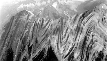
Sullivan River, British Columbia. Folded sedimentary layers suggest great tectonic violence in the past. No sign of tensile cracking and no sign of erosion on this razor-sharp mountain top. (Geological Survey of Canada, Ottawa: photograph number 180345) |
Lyell and modern geology acknowledge that the rock layers were first
formed as flat sediments, which were soft and plastic in their early stages.
With time and, it is said, heat and pressure, these sediments lithify and
by compaction and cementation become hard, solid rock. Lyell required long
times, but it is just those long times that worked against his theory by
causing the sediment to harden before, or certainly during, bending.
He made the a priori assumption that the natural laws operating
today have not changed, but then because of the obvious problem of bending
solid rock, he had to make an appeal to time as a factor that somehow changes
the laws by which rocks crack when their tensile strength is exceeded;
this is a contradiction of his own principle of uniformitarianism. All
this difficulty would have been avoided if Lyell's mind-set could only
have accepted the most obvious explanation, that the rocks were bent in
the early stages when the sediments were pliable and before lithifying
took place. This would easily satisfy all the facts but would require the
process to have taken place over a short period of time, say, a few months;
but, of course, it would be difficult to then escape the conclusion that
a major catastrophe was involved.
Those Anomalous Fossils
| Geology surely loses credibility as a science when it is discovered, for example, that a fossil life form declared to be extinct millions of years ago suddenly appears alive in a fisherman's net. It is usually claimed that the supposedly extinct creatures survived for millions of years in some isolated ecological niche, but this assumes absolute uniformity of conditions, which, it is admitted, is extremely unlikely. |
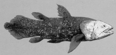
Coelacanth Fish - The coelacanth (Latimeria chalumnae) believed to have been extinct for some 70 million years, turned out to be alive and well with virtually no sign of evolutionary change. (Author's collection) |
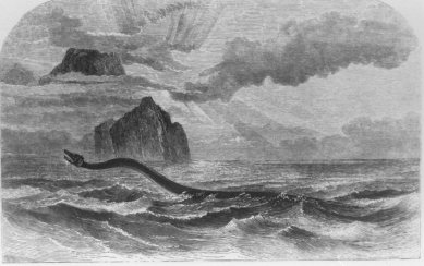
Imaginative reconstruction of a sea-serpent from fishermen's accounts. (Engraving produced in 1860; Thomas Fisher Rare Book Library, University of Toronto) |
Of all the fossil creatures, the dinosaur is the largest and probably best exemplifies the prehistoric age. It is perhaps only remotely possible, but should a live dinosaur be discovered, this would cause the most heated controversy; its very being would challenge Lyell's geologic column and the theory of evolution. Some hint of the arguments likely became evident in April 1977, when a Japanese fishing vessel caught a 4,000 pound dead creature in its nets off the east coast of New Zealand. From photographs, sketches with careful measurements, and flipper samples for tissue analysis, it had every appearance of being a plesiosaur, or sea-dwelling dinosaur, which has until now only been known by its fossils. Unfortunately, the fishermen had to return the dead creature to the sea to save their fish cargo, but the evidence, such as the tissue analysis, showed that it was clearly not a mammal. Meanwhile, the measurements of the head and neck and the absence of a dorsal fin discounted the possibility of its being a basking shark. Nevertheless, Western scientists insisted that it was either a sea lion (mammal) or a shark, but most of the Japanese scientific community was convinced that it was indeed a plesiosaur (Koster 1977).[33] |
| We are repeatedly told in newspaper articles, magazines, and
textbooks that 70 million years ago, at the end of the Cretaceous period
and the beginning of the Tertiary period, three quarters of all the known
species of animals living in the water and on the land became extinct.
This included all the dinosaurs, while the reason for their extinction
has been the cause for dozens of theories. The latest, by Alvarez et al.
(1980), suggests that the earth was hit by some giant meteorite from space.[34]
Not that a catastrophe is being suggested here, of course, but by some
convolution of mind a "slow catastrophe", perhaps taking a million years,
is proposed! Such speculation will no doubt continue to fill the pages
of professional journals in the future as they have in the past; Arctic
spillover as proposed by Gartner and McGuirk (1979), is another example.
|
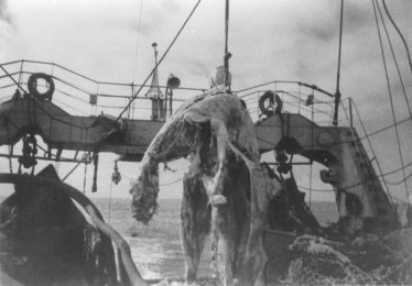
Dead creature caught by Japanese fishermen near New Zealand in 1977. A qualified marine biologist on board the vessel recorded all the pertinent data possible. (Taiyo Fishery Company, Japan). (LEFT) His sketch of the dead creature has been redrawn
|
According to the geologic column, man did not enter the primeval scene
until a million years ago -- quite recent in geological terms -- and with
a gap of at least seventy million years between the extinction of the dinosaur
and the emergence of man. Evidence that suggests that man and dinosaur
were contemporaneous would tend to upset the concept of the geologic column,
especially since it is so precariously balanced on a series of assumptions.
In the limestone bed of the Paluxy River near the little town of Glen Rose,
Texas, there are some magnificent dinosaur foot tracks. Running parallel
to and between are what appear to be human foot tracks -- five toes, ball
and heel, spaced apart -- left foot, right foot. These were described by
Roland Bird of the American Museum of Natural History, New York, in 1939.[35]
In 1940, the American museums removed large sections of the dinosaur tracks
from the river bank, which have since been on display at the Smithsonian
and other museums, but no mention is ever made of the human-like tracks,
which were carefully excluded. In the May 1954 issue of National Geographic
magazine,
Bird had a full-length article on the dinosaur tracks at the Paluxy River,
but, again, no mention was made of the human-like tracks.[36]
Some have claimed that these tracks were carved by the local inhabitants,
which is possible, since good money was being paid for curios. However,
in 1969 a documentary film was produced in which fresh tracks were exposed
by damming the river. With earth-moving equipment, part of the limestone
bank was removed to follow existing tracks. Good quality prints were exposed
and a number of geologists invited for their opinion. Their recorded reactions
were interesting, but in the end, they defended the theory and rejected
the evidence. True science is supposed to apply inductive reasoning; if
the evidence does not fit the theory, the evidence is verified, and, if
found to be valid, the theory is then questioned.
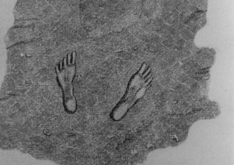
This engraving showing human feet impressions in Limestone rock near St. Louis, Missouri, was published with a descriptive text by Henry Schoolcraft in The American Journal of Science for 1822. Apart from the questions the picture invites, it is notable that it was reported at all in a professional journal of that date. Reports of similar findings would not be accepted by any reputable journal today. (Science and Medicine Library, University of Toronto) |
Recently, more human-like tracks have been found in the limestone strata of the Paluxy River, together with dinosaur tracks.[37] Again scientists were invited to inspect these fossil impressions. The opinion was that the impressions were made by the dinosaur's "elbow", and it was asserted that the toes were "added" recently by being carved in the rock. The impressions are real enough, while the carving, or at least scratch marks, may well be likely. It might be asked, however, who would go to this much trouble? It can be appreciated that for those with a vested interest in the orthodox geological view to add scratch marks to existing toe impressions with the intention of discrediting genuine evidence is far easier and the motive more compelling than it would be for those with an interest in an alternate view actually to carve the toe impressions and risk all credibility. Many more human-like tracks have been discovered all over the United States (Schoolcraft 1822) and Ingalls (1940) has pointed out that they cannot all have been carvings.[38 ] The evidence at Glen Rose, which would challenge Lyell's nineteenth century geology, needs to be seen firsthand since it is unfortunately ephemeral in the sense that it is being dissolved by acid rain, is difficult to record on film, and is in constant danger of vandalism. |
An Alternative View
A quarter of a century ago Velikovsky (1955) produced a massive indictment against Lyell's uniformitarian doctrine of geology with evidence from all over the earth of past catastrophes of a worldwide nature. DeGrazia (1966) has exposed and censured the intemporate attacks made on Velikovsky by the natural scientists, and it is evident that the published facts posed a threat to the established belief system. Not insignificantly, many were those with vested interests in the textbook market. We do not necessarily have to accept Dr. Velikovsky's interpretation of the evidence -- in fact, some of his interpretations have since been disproven -- but it is surely not in the spirit of true science to sweep the evidence under the carpet just because it does not support the nineteenth century ideas of Lyell. Yet, it is just these geological principles of Lyell, based on the greatly expanded time frame for the early history of the earth, that form the foundation for Darwin's theory and its subsequent variations.
Chapters Eleven and Twelve present some good evidences for a young earth and, while they do not conclude with an actual age, they do offer a challenge to Lyell's expanded time frame. Of course, evolution of any kind would be impossible in an earth reckoned in thousands rather than billions of years. Faced with these evidences and a young earth, the biblical model of the single, worldwide Flood may then begin to appear the more reasonable model. For example, it is still necessary to account for the marine fossils on the mountain tops.
The biblical description of the Flood states that it began with an unprecedented rainfall of forty days while the sea level rose continuously for five months until every mountain was entirely covered with water. Many of the mountains familiar to us today have evidently been uplifted since the Flood so that the water level need not necessarily have risen 30,000 feet to cover, say, Mount Everest. Possibly only a few thousand feet of water were necessary but at the same time the continents may have sank. Within the general turmoil, volcanoes would certainly have been very active, spewing out vast quantities of ash, much of which would have been ejected underwater as a sort of cement-like slurry. Superimposed on all the general turmoil of the Flood would be the effect of the moon's gravitational pull on the worldwide ocean. At the present time the moon pulls up a "bulge" of water, and the earth rotates beneath it. This bulge eventually meets the shoreline and is seen as the tide coming in, but the waters never go beyond their prescribed limits. However, the Genesis Flood was global meaning that the earth rotated beneath a continuous film of water permitting the buildup of tremendous tidal currents. The velocity of the water laden with sediments could have been significant directly beneath the bulge caused by the moon but taper off to nearly zero towards the earth's poles. The process would distribute great quantities of sediment and lead to a complex but, nevertheless, organized imposition of forces upon the deposition rates of sediment and suspended matter. According to the Genesis account the Flood lasted 376 days.
In 1961 Whitcomb and Morris produced The Genesis Flood and that has since become a classic work on the dynamics of the Flood. The authors carefully examined the geological evidence and proposed two possible mechanisms that were likely responsible for the fossil distribution. The first was that the rising waters of the Flood buried the living creatures in their habitat, thus we would expect to find oysters at the bottom of the column, fish above this, then reptiles on the low-lying land and finally man near the top as he sought the high ground (Morris 1961, 273). This explanation has its problems, however, and only explains the first appearance of life forms in the geologic column and not, say, the fossil fish on the mountain tops. The second proposed mechanism was based upon hydraulic sorting. This is a process well known to mining engineers and commonly used in the extraction of, say, tin ores from crushed rock. In rapidly moving water, suspended solid particles drop to the bottom in a definite order: dense matter, such as clams and trilobites, would settle first and finish in the lowest stratum, whereas birds and hairy ungulates would remain suspended longer and finish near the top of the stratum.
Clearly, experimental work on sedimentation was needed to test these proposals. Almost thirty years later, Guy Berthault and others working in France, carried out a series of experiments with sediments in flowing water. This work demonstrated that hydraulic sorting, otherwise known as pro-gradation, does indeed take place during a flood and this has contributed significantly to the general understanding of Flood dynamics. The importance of the work is that it shows conclusively that the fossil-containing sediments, that is, the geologic column, can better be explained by simultaneous deposition from one flood rather than sequential deposition from multiple floods; the time frame is thus reduced from millions of years to a few months. The known existence of continuous deposits of stratum encircling the earth and the gradual transition from one type of strata to the next are powerful evidences of one flood over a short time period. Berthault's work has continued but, as far as is known, is confined strictly to sediments, i.e. dead animals have not been included as "sediment." The work is reported mostly in the French scientific literature (Berthault 1988).
Finally, in 1980 Walter Brown, introduced his hydroplate theory to address
the problem of the origin of the Flood waters and where they later went.
This work was not so much concerned with fossils in the geologic column
but rather the processes most likely taking place deep within the earth's
crust that caused the Flood. The hydroplate theory is firmly grounded upon
Scripture and upon well-known chemical and engineering principles; it makes
no appeal to miracle. Brown first points out that the vapor canopy theory,
mentioned later in Chapter 12 and popular with many creationists, is completely
unworkable. He sets the calculations before his readers to show that the
collapse of a modest canopy of vapor or even ice particles would produce
far too much heat for any living thing to survive. This would include Noah
and his ark. The hydroplate theory proposes that prior to the Genesis Flood
there was a large volume of salty water held in interconnected subterranean
chambers. Gradually increasing downward pressure on this water and the
rock pillars holding the crust in place was brought about by energy transfer
from the moon. That is, the daily tides, not only of the ocean but of the
crust itself, transferred this energy into heat and mechanical pounding
of the subterranean pillars. Eventually, all this caused a rupture of the
earth's crust followed by enormous fountains of hot salty water. The rapid
release of pressure reduced the temperature of these fountains of water
and they fell back to earth with their associated sediments as the "forty
days rain." As the ocean levels rose, the hot salty juvenal waters continued
to pour out through the rupture eroding the vertical sides and producing
enormous quantities of sediment. At the same time, the continents sank
as the crust collapsed into the former subterranean chambers. Finally,
less dense portions of the crust were forced upwards as they became displaced
by the more dense parts of the crust. Geologists are well familiar with
this type of exchange process and know it as isostasy. These rising parts
of the crust formed the new continents likely very similar in form to those
we know today. Dr. Brown has continued to work on the hydroplate theory
and has discovered that many other natural phenomena, such as the origin
of meteorites, are more completely explained by this mechanism. (Brown
2001).
Lyell's Geology Has Its Problems
Very seldom are the unsolved problems of conventional geology brought
to the public attention, but in 1973 Derek Ager, a well-respected professor
at University College of Swansea, published a small compendium of these
problems, intended to stimulate fellow geologists into finding solutions.[39]
The overriding constraint, however, was that the canon of faith in the
millions of years demanded by the theory of evolution should not be violated.
The result has been that the problems remain unsolved! However, even without
this constraint, many of these problems actually become evidence for the
universal Flood. One example given by Ager and known as the "persistence
of facies", will be considered (Ager 1973, 1-14). Facies are described
as sedimentary rocks having similar characteristics, and, when found on
a worldwide scale, are referred to in orthodox geology as "persistence
of facies". Ager describes the unusual white chalk deposits containing
black flint stones like currants in a pudding and which also contain the
small identifying marine fossils Micraster and Echinocorys. This
very specific kind of sedimentary rock is found to extend in a band from
western Australia to Texas, Arkansas, Alabama, and Mississippi, then to
northern Ireland through England to become the famous white cliffs of Dover,
to northern France, Denmark, northern Germany, southern Scandinavia, to
Poland, Bulgaria, and eventually Georgia in the Soviet Union, and the south
coast of the Black Sea. This phenomenon, which, Ager points out, occurs
with several other types of rock formation, has never been adequately explained
by Lyell's geology in which each rock formation is believed to have been
deposited separately in time and space. However, the "persistence of facies"
is exactly the kind of evidence that would be expected from a single universal
flood having a complex but organized imposition of forces on the deposition
of sediment and suspended matter.
| Orthodox geology is more and more beginning to acknowledge that there have been local catastrophes in the past, and the positions of orthodoxy and those who hold to the literal biblical view with subsequent floods may in time begin to coalesce (Cowen and Lipps 1975).[40 ] Certainly the flood model suggested can better explain the fossils that are occasionally found in drill cores and recognized as being "out of order"; it must be remembered, however, that they are only out of order so far as the evolutionary interpretation is concerned. The alternative model can also account for human artifacts reported from time to time in the lower strata of the geologic column and that become surrounded by controversy if they are reported at all. The fossils out of order on a massive scale, such as those that identify the entire top of the Matterhorn or the fossil trees found standing upright traversing "several million years" of strata, can all be better explained in terms of successive catastrophes over a few centuries (Lyell 1845, 2:155).[41] There are many other geological anomalies of this type, which may be resolved more simply by the universal flood model, which is not based on circular arguments or a chain of assumptions, and it is suggested that science should be free to explore this or any other model. After all, it was precisely the same lack of freedom to explore under Cuvier that retarded scientific progress in the French republic for more than half a century. |
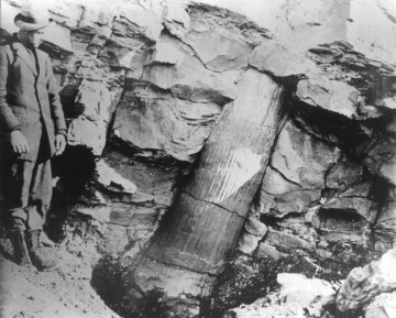
Polystrate fossil tree passing through sedimentary rock suggesting rapid deposition. Joggins, Nova Scotia. Geological Survey of Canada, 1910. Neg. 15092. |
|
|
| << PREV |
|