|
|
|
|
|
|
|
|
|
|
|
|
|
|
 |
|
|
to the Hava Supai Canyon, Northern Arizona OCTOBER AND NOVEMBER, 1924 |
Compliments of
OAKLAND, MUSEUM
OAKLAND, CALIFORNIA
Sponsor and Patron
E. L. DOHENY
DIRECTOR OF EXPEDITION
SAMUEL HUBBARD
Honorary Curator of Archaeology of the Oakland Museum
SCIENTIST
CHARLES W. GILMORE
Curator of Vertebrate Paleontology, United States Rational
Museum
PHOTOGRAPHER
ROBERT L. CARSON
SCULPTOR
JOSEPH F. ROOP
Assistants
FRED V. SHAW
ARTHUR METSZER
GUIDE AND PACKER
BUD CLAWSON
FOREWORD "Out of the Universal, Truth calls its own, lighting its beacon fires upon the mountain tops to attract the wayfaring pilgrim in the valley."
FABRE. D'OLIVET

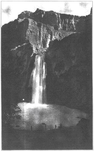
THE HAVA SU FALL, 125 feet high (formerly called the Bridal Veil). |
THE Doheny Scientific Expedition to the Hava Supai Canyon in Northern Arizona, was organized for the express purpose of bringing before the scientific world, certain discoveries relating to prehistoric man made by the writer, in three previous visits to this isolated region. It so happened that Mr. E. L. Doheny of Los Angeles, who sponsored the expedition, had visited this canyon as a young prospector, in 1879. He and his party were among the first white men to venture into this wild place, and the hardships they endured, and the dangers they faced were made apparent by the fact that one of their party, a sailor named Mooney, lost his life while trying to descend below the fall which to this day bears his name. The Hava Supai Canyon is formed by Cataract Creek which rises on Mt. Bill Williams and joins the great Colorado river about 150 miles west of the Bright Angel Trail (see sketch map). After meandering over the high plains for 50 miles this stream suddenly forms a "Box Canyon." Starting on top of the "old Red Sandstone" of the carboniferous ("Supai formation") it eats its way deeper and deeper into this formation, with the red walls rising ever higher on either side. About 30 miles from the head of the "Box Canyon," the red walls widen out to form a secluded little valley which is a veritable oasis in a vast wilderness of rocks. Here the government maintains the Supai Indian Agency which administers to the needs of 186 Supai Indians. The place where the walls begin to widen is the contact between the red sandstone and the Silurian lime. Out of this contact flows a mysterious subterranean river which never varies summer or winter. This river flows through the valley for about 3 miles and then forms three beautiful falls on its way to join the Colorado. |
The water is slightly warm at the point of emergence and is so surcharged with lime that everything coming in contact with it for any length of time is turned into limestone. Notwithstanding this it is a good drinking water and the Indians use it to irrigate their fields. The arable land is only about 500 acres in extent and this water is the factor which makes it possible for these Indians to live there.
That this water supply was a potent factor in the lives of prehistoric people is evidenced by the many inscriptions on the walls of this canyon which it is the purpose of this pamphlet to describe.
The Government Survey gives the elevation of this valley as 3195 feet above sea level, while the higher surrounding plains are from 6200 to 6700 feet in elevation.
To reach this valley from the El Tovar Hotel it is now possible to go 35 miles by automobile to the Government warehouse at the "Hill Top." At this point the "Tobocobe Trail" proceeds down Lee Canyon to its junction with the main Supai and thence down the Supai Canyon to the "Village" or Agency, a total distance of about 15 miles.
This canyon was first visited by the writer in November, 1894, and in February and March, 1895. Most of the matters of prehistoric interest described in this pamphlet, were observed at that time but their true significance was not fully recognized. Endeavors were made at various times to interest scientists in this discovery, but without avail.
It is only within the past two or three years that discoveries made in Yucatan, Mexico, and the western states prove to the most conservative that a race or races of men of very great antiquity inhabited North America.
The fact that some prehistoric man made a pictograph of a dinosaur on the walls of this canyon upsets completely all of our theories regarding the antiquity of man. Facts are stubborn and immutable things. If theories do not square with the facts then the theories must change, the facts remain.
It is our endeavor to set forth, as clearly and briefly as possible, the facts exactly as we found them, and give an outline of the conclusions to be drawn from them.
The Doheny Scientific Expedition wishes to make grateful acknowledgment to Mr. Stephen Mather, Director of National Parks, for his assistance in sending Mr. Charles W. Gilmore of the National Museum, as a scientist attached to our party. Also to acknowledge the courtesies extended by Park Director Eakin of the Grand Canyon National Park and by Chief Ranger Scoyen, and to Mr. and Mrs. Lovenskiold, Indian Agent at the Supai Reservation. Also to the Harvey people at El Tovar for prompt service and competent assistants.
Thanks are also due to Mr. Howard Throckmorton of Los Angeles, for his friendly interest and constructive help toward the success of the undertaking. To each member of the expedition thanks are extended for loyal and competent service under conditions calling for some hardships and some danger.
|
|
|
|
|
|
|