|
|
|
|
|
|
|
|
|
|
|
|
|

The article below (from "A Symposium on Creation" Vols. 1-5 @ http://www.creationism.org/english/symposium/) is used by permission of Baker Books, a division of Baker Book House Company, copyright ©1968-1975. All rights to these materials are reserved. Materials are not be be distributed to other web locations for retrieval, published in other media, or mirrored at other sites without written permission from Baker Book House Company.
The Ice Epoch
by Donald W. Patten
From: "A Symposium on Creation"
Vol. I, pg 119-138
©1968 -
Baker
Book House
Knowest thou the ordinances of heaven?
Canst thou set the dominion [or application] thereof in the earth?
(Job 38:33)
The subject of this chapter is ice, and ice in rather vast amounts (at least from our current perspectives). How much ice was involved in the Ice Epoch? Where did the ice come from? Where was it deposited? How suddenly did it appear? How rapidly did it melt off? When did it occur? Out of whose womb came the ice?
Again, we should briefly sketch traditional thinking concerning the Ice Epoch, the so-called Ice Age or Ice Ages. Within uniformitarian thought, there has been a requirement of five, six or perhaps seven Ice Ages. For instance there are rocks with attributed ages of 200,000,000 years which have striations. So there had to be an Ice Age at that time. Later, dinosaurs roamed Arctic prairies, so there had to be a recession of the ice. Dinosaurs supposedly died out about 60,000,000 years ago, and yet they were followed by mammoths, some of which were enveloped in some rather icy conditions. By the time the geological time scale is applied to the fossil data, ice ages are coming and going almost constantly in what is known as "Mesozoic" and "Cenozoic" time.
My understanding is that the two zones of mountain uplifts which were demonstrated did not occur 130,000,000 to 200,000,000 years ago, but rather something like 5,000 years ago, and during the same year, the year of Noah's crisis, the year of Noah's flotation. Thus uniformitarians, if they acknowledge a flood at all, will all agree that the Ice Epoch, the so-called Ice Ages occurred prior to the Flood.
Yet some rather well-oriented catastrophists, mostly fundamentalists in their view of life, men like Price, Nelson and others have noted that the Flood caused a vast amount of sedimentation, forming layer after layer of strata. And such formations have been scoured out. Their proposition has been that the Ice Epoch could not have preceded the Flood, but rather must have followed it.
There are a whole series of specific considerations to which we might at this time direct our attentions. Such considerations might well include such items as lateral moraines, terminal moraines, drumlins, erratic boulders, striations, drowned continental shelves, quick-frozen or flash-frozen mammoths, ice caves in lava plateaus, ice flow patterns, glacial lakes, diverted river systems and the like. But before we dig into some of these specifics, it may be well to take an imaginary airplane trip, an airplane trip during the Ice Epoch, and we may view, in our mind's eye, our imagination, the location, the dimension and the scope of this icy blanket.
All who travel today by airplane know something of aerial views, aerial views from as high as thirty thousand and forty thousand feet, a rather panoramic perspective. From Seattle to Houston, via Portland and Dallas, a distance of two thousand miles, one can see on the way the snow-encrusted extinct volcanoes known as Mt. Adams, Mt. Hood, Mt. Rainier and Mt. St. Helens.
Let us imagine another plane trip, a non-stop flight, a distance of about fifty-five hundred miles. In our imaginary flight, we embark just south of the flowing edge of the ice mass, at a location where the mighty Columbia and the Willamette meet, now known as Portland. We fly north about eighty miles, and we begin to see the edge of the ice mass in some broad tongues, near what is today Chehalis, Washington.
We proceed into the Puget Sound Country, but there is no Puget Sound; sea level is perhaps three hundred to four hundred feet below the current level, and has not flooded Puget Sound. Puget Sound is merely a valley of ice, with its bottom being deeply scoured out. In fact there are a whole series of valleys of ice, with occasional lateral and terminal moraines in the process of formation, moraines some five hundred and nearly one thousand feet high, stretching like long ridges around the ice flows.
Our airplane climbs, and we proceed across the icy Cascades where a whole series of fresh volcanoes are belching out their smoke and lava. Crossing British Columbia, hundreds of rugged mountain peaks are dotted among the ever-increasing blanket of ice, many half-buried, and some almost completely buried.
Then we cross the majestic Rockies, with their knife-like sawtooth faces. And we see our last mountain peak. Crossing Alberta and Northern Saskatchewan, we see nothing but dazzling, blue-white ice, in one, vast, unbroken landscape.
As our plane crosses into the Northwest Territories, it rises to seventeen thousand feet in altitude. It has to rise or it will crash into the ice mass, the so-called Keewatin Node, located east of Great Slave Lake. And then our airplane passes other nodes such as the Labrador Node, of a similar elevation. Crossing Davis Strait, leaving Baffin Island, and approaching Greenland, our plane drops a little in altitude, for the ice mass is not quite so deep; nevertheless no ocean is seen, and no Greenland is seen. Only ice appears in a vast, unbroken blue-white blanket of ice. This is all that is visible of Iceland.
Proceeding eastward, a ridge of mountains appears, on what is today known as the Fenno-Scandinavian Shield. Eastward and southward, one crosses southern Sweden and the Baltic Regions, and suddenly a hill or two come into view, poking their ridges out from the blanket of ice. Flying deeper into Germany and Poland, tongues of ice are seen now between ranges of hills. Glistening rivers are draining off vast volumes of melt water. And shortly, little ice is seen, except in the Alpine regions. The ice mass has been spanned. Our plane trip covered some fifty-five hundred miles, and apart from some mountain ranges and volcanic cones, it was one, vast, mass of shifting, flowing ice, from one contỉnent to another.
In our plane trip we crossed not only the top of the ice mass, but we also passed the magnetic pole almost directly. But we did not come within twelve hundred miles of the geographical pole.
We saw a mass of ice which may have included eight million to ten million cubic miles of frozen water. And apparently a similar amount was located in the Antarctic Region. This is a lot of ice to see. It is a lot of water to refrigerate. It requires many septillion calories of heat exchange. And it would appear to this writer that such catastrophists as Nelson and Price were correct when they deduced that this vast icy view, this vast icy mass, was formed, or at least flowed out after the Flood. Correction. We do not say it was formed after the Flood, but it did outflow after the Flood. Again we repeat the question, "Out of whose womb came the ice?" (Job 39:29 ). And its corollary question is also brought to attention, paraphrasing Job 39:30. "When were the waters congealed like a stone, and when was the face of the deep frozen?"
With this vast icy perspective in mind, and this great cosmological question asked, it may be time to begin reviewing some of the perspectives and circumstances, circumstances which individually are pieces of this great puzzle in earth history.
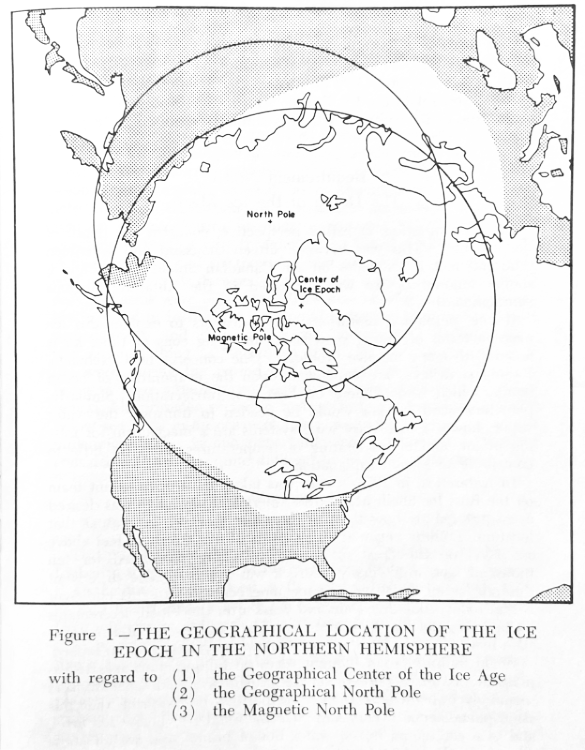
It has already been noted that the ice mass was centered, strangely enough, not over the geographical north pole where so little sunlight falls. Rather it was centered over the magnetic pole, some twelve hundred miles distant.
The location of the ice mass was about fifty-two hundred miles in diameter; its depth was about three miles in thickness. It might be viewed like an icy pancake, a blanket which was slightly deeper in the center than elsewhere, and its depth feathered out toward the edge or the periphery. The location of the ice mass was rather eccentric to, say, the location of the Arctic Circle. Figure 1 demonstrates this.
Today, Northern Siberia is the coldest place on earth, with the possible exception of the offshore islands north of Siberia. These islands, along with Antarctica, are the two regions on earth today which are truly uninhabitable. Yet these islands were not glaciated by the ice mass; they were not covered by the ice mass. This area today contains some rather handsome, flash-frozen mammoths and rhinos, some with apparently subtropical types of vegetation and humid temperate types of vegetation in their stomachs, yet undigested, and in their mouths, yet unswallowed. Trees with pine cones are found quick-frozen, as are elderberry trees with ripe berries. But this region was not glaciated.
The ice mass just did not bear the same geographical pattern as do, say, annual isotherms or monthly isotherms today. For instance in Washington, Chehalis, latitude 47° N., was glaciated, whereas Novaya Zemlya, latitude 75° N., was mostly not glaciated. Lakes Erie and Michigan, latitude 42° N., were scooped out by the tongues of the flowing ice mass; yet Bennett Island, the northernmost of the New Siberian Islands, was left apparently unscathed by glaciation at the time of the Ice Epoch. Bennett Island has a latitude of 76° N.
With regard to:
And in central Illinois, Indiana, and Ohio, the ice mass flowed to a latitude of 39° N. latitude, more than half of the way to the equator. Yet Severnaya Zemlya (Northern Land), latitude 79°, was hardly touched. This geographical location bears an associative relationship to the magnetic poles, as well as to the Aurora Borealis. But its geography is hardly the geography of the Arctic Circle, and the geographical north pole. Why was this so? An answer to this perplexing problem will be developed later in this chapter.
How much ice was contained in this ice blanket, or ice sheet? We have already suggested the answer, which lies between fifteen million and twenty million cubic miles of ice for the two ice sheets located over both magnetic (and geographical) poles. There apparently was perhaps eight million to ten million cubic miles of ice in the northern ice sheet.
This is a lot of ice. If it were spread evenly across the planet it would make a layer about four hundred feet deep. Think of four hundred blocks of ice, each one foot cubed, stacked upon a small desk. This gives you an idea of the amount of ice which is required to explain the Ice Epoch. And it gives you an idea of the magnitude of refrigeration which is similarly required for explanation.
Our next question, or rather perspective, concerns the depth of the ice mass. This was between fifteen thousand and seventeen thousand feet in its nodes on the Canadian Shield. Seemingly a similar amount of ice was deposited in the Antarctic Regions simultaneously.
If one, perhaps a uniformitarian, endeavors to explain this ice mass in terms of falling snowflakes, and long eons of time, he is faced with many massive problems. One concerns heat exchange. Falling snowflakes are dependent upon the evaporation of ocean water, which is dependent on heat, not refrigeration. Similarly, planetary wind systems would be needed to transport the water vapor; however, planetary wind systems are a mechanism for mixing of air, and of moderating of temperatures; both do little to contribute to a solid explanation.
In Antarctica, in 1958, a core was taken by a government team off the Ross Ice Shelf, near Little America. Knowledge was desired as to just exactly how thick or deep the sheet of ice was at that location. Drilling began at an elevation of five thousand feet above sea level on the crust of the ice. Drilling proceeded for ten thousand feet, until finally bedrock was reached. The drill went through ice all the way. The meaning contained in this endeavor is that today, some five thousand years after the Flood, ice remains on bedrock, not five thousand feet above sea level, but five thousand feet below sea level, where it snows very, very seldom indeed.
When uniformitarian thought relies on falling snowflakes to explain the ice mass, perhaps on the Canadian Shield, such thinkers seemingly trap themselves into the position of requiring that this same phenomenon occurs some five thousand feet below sea level, and in a continuum not of water but of brine. And we all know what just a little bit of salt will do on a frozen pavement.
It may seem as if this subject of the Ice Epoch stretches from the sublime to the ridiculous. Yet any uniformitarian explanation, to be thorough and consistent, must take such a preposterous position. It is not the only ludicrous proposition in the "slow-snow" theory, but it demonstrates the need for better explanations. Again, the real question is not whether the uniformitarian approach is coherent. The real question is, "Out of whose womb came the ice?"
We would bring to your attention, at this juncture, a parallelism which we cannot take time to develop; nevertheless it should be noted. In Section V, it was seen that mountain systems were raised up, in an arcuate alignment, sweeping across the surface of the earth in Great Circle patterns. These arcuate uplifts traversed oceanic basins equally as easily as continental massifs. Now also note that ice deposition has occurred, apparently equally as easy on oceanic basins as upon continental shields. This is a parallelism. Further note that during the Flood, if there were tides of five thousand and six thousand foot magnitudes, not only were continental massifs drowned or washed in tides, but simultaneously oceanic basins were uncovered. This may be why so much marine life is found in fossil form in hill and mountain terrain; the oceans surged forth, and their debris was swept out. Perhaps there was no such thing as "mean sea level" in the ordinary sense of the word during the period of the Flood catastrophe. Thus we bring to your attention, without further development, the rather remarkable presence of ice in hydrosphere, ice five thousand feet below sea level in an ocean of brine, remaining there even to this millennium. This is one remarkable location for ice deposition; consider another one, quite different but equally remarkable.
This phenomenon also occurs in Eastern Oregon and in Southern Idaho, in what is known as the Columbia Plateau, a lava plateau.
At the time of the Flood, with vast tidal forces enveloping the earth, I feel that the crust of the earth was tortured simultaneously from within (by upthrusts of lava) and from without (by oceanic tides washing around). The crust of the earth was in something like a bellows-like circumstance. Upheavals of magma occurred, squeezed up in this gravitational crisis involving our rotating planet. In some places mountain ranges were the product, a deformation of the earth's crust. In some places, lava bled through a fissure and formed a volcanic cone. In other places, lava bled through a fracture and formed a large, basaltic plateau. The Deccan Plateau in India is an example. So is the Columbia Plateau in the Pacific Northwest. Only in the region of the Columbia Plateau, incoming ice, and inflowing ice mixed with the upwelling lava in a unique commingling.
In the Pacific Northwest today, many ice caves are found. When cuts were blasted out of the volcanic hills near Grand Coulee for highways, pockets of ice were encountered. Today, Skamania County, located between the volcanic cones of Mt. Hood, Mt. St. Helens and Mt. Adams, is known to contain more than twenty ice caves. Deschutes County, Oregon, contains many ice caves, sandwiched in between lava formations.
The writer examined one ice cave about fifteen miles down- stream from Grand Coulee Dam in Douglas County, on the Norman Alling ranch. This ice cave had been used for the refrigeration of beef during the hot summers when the neighbors were resigned to salt pork. Even today, the Alling family has a tradition of gathering on the fourth of July, and among the festivities is chipping some ice from the cave, several hundred yards from the house, and using it in conjunction with an old-fashioned crank-operated ice cream bucket. And ice cream is made from fresh ranch cream and ice, which must be considered to be at least five thousand years old in terms of its terrestrial existence.
As one enters this cave, he is impressed by the cold wind emanating from the cave, and the icy stalactites and stalagmites protruding from the lava formations. The fact that ice has been sandwiched in between lava formations is obvious, but it could hardly have been accomplished by falling snow fakes, even over unending eons of time. The fact that some ice has melted is obvious; such melting is the reciprocal of the caves themselves. The fact that much ice remains is also obvious, which is suggestive that the entire formation is recent in terms of millennia, and not ancient in terms of millions of years.
For instance, the climate in this region averages around 42° annually, summer and winter, day and night. The summers are sufficiently warm to grow good crops of peaches in the lower valleys, as well as other types of soft fruit. Temperatures within the earth's crust do not diminish; rather they increase, and at the rate of 16° per one thousand feet. Some fifteen thousand feet below the surface, temperatures exist which will convert water into superheated steam. And yet, within this climate, and within this lava formation, an ice cave exists.
It was inspected by Mr. Arthur Kalmen along with the writer. Mr. Kalmen was an employee of the Bureau of Indian Affairs at the time, a graduate in agriculture from Washington State College. We estimated the volume of water low from the spring at the base of the hill. Mrs. Alling stated that Mr. Alling had taken its temperature many times during the last several decades. The temperature was always 34° F., summer or winter, day or night.
This writer estimated the rate of flow from the spring at five gallons per hour, an estimate considered quite conservative by Mr. Kalmen. And we both ignored seepage. Yet by projecting an hourly flow of five gallons into five thousand years, one must conclude that over one million tons of ice have melted and, unquestionably, much yet remains, sandwiched in between these basaltic formations. "Out of whose womb came the ice?"
Ice deposition in the hydrosphere, five thousand feet below sea level on the Antarctic Shelf is one thing, but ice deposition between lava formations is quite another thing; both require explanation. And I am convinced that if we can make correct catastrophic assumptions, and rid our thinking of our uniformitarian subconscious assumptions, a correct explanation shall not be very difficult to achieve.
Ice today forms where snowfall exceeds melting and outflow. The result is a glacier, usually high in the mountains, but lower down in Alaska. Between seven and nine inches of snow will compress into an inch of ice. If we are going to explain fifteen thousand feet of ice, we must multiply this fifteen thousand by twelve inches, and re-multiply by the seven, eight or nine factor relative to the compression of snow. The result is something over one million inches of snowfall.
Snows occur in mountainous regions where winds are forced upwards and are compelled to discharge their water vapor. This is called orographic precipitation. Another type is cyclonic precipitation, which is the result of storm fronts where cold polar air masses mix with warmer, humid, maritime air masses. The result of the mix is snow, often a blizzard.
In the Pacific Northwest, where the Cascades catch much orographic precipitation, snowfalls of ten feet are fairly common; snowfalls of fifty feet are unheard of. But concerning an explanation for the Ice Epoch, we are talking about a snowfall of hundreds of thousands of feet, and that not in a mountainous region, and not anywhere near an ocean, a source for precipitation. On the Canadian Shield, some one thousand miles from the Pacific Ocean, one locates the Keewatin Node, near the magnetic pole.
The pattern of snowfall in Antarctica today is a peripheral pattern, or a saucer-shaped pattern. Snow falls on the edges of the continent, where marine, saturated air mixes with cold polar air. But in the heart of Antarctica very little snow falls. One reason is that the temperature of the air is too low to contain much water vapor. Another reason is that marine air seldom penetrates deeply into the Antarctic continent. The heart of Antarctica has been compared favorably with the heart of the Sahara Desert in terms of precipitation.
However concerning the pattern of the ice dump, it was not saucer-shaped as it is in Antarctica today, where it is higher toward the periphery where snows fall in greater amounts. Rather the shape was rather conic, some three miles thick at the central nodes, feathering out twenty-five hundred miles in its radius. It may be described as "pancake-shaped," an icy pancake five thousand miles in diameter. Is it possible that ice was suddenly dumped over the magnetic pole some five thousand years ago?
The flow pattern of a fluid, suddenly dumped out, is radial, like pancake batter on a griddle, or like milk spilled on the floor. The flow pattern of a fluid, gradually forming and draining over greater lengths of time, is a dendritic or river-like pattern.
When the ice began to flow, it flowed over hills a thousand feet high, and flowed on for hundreds of miles. It scooped out such basins as Lake Erie, Lake Michigan and the Puget Sound, and, we must suspect, with relative ease. The ice flow did not concentrate in the valleys and avoid the hills. It flowed over both en masse. The radial flow pattern of the Ice Epoch is again suggestive that whatever happened, it happened suddenly.
A vast number of ivory tusks have been gathered throughout Northern Siberia in recent millennia. Demosthenes' father-in law traded in Siberian ivory. Piano keys of Europe during the seventeenth and eighteenth centuries were made more often from mammoth ivory than from African ivory. One mine in Siberia reportedly yielded twenty thousand tusks. When Vitus Bering, the Danish explorer of the Arctic, visited Bear Island, north of Siberia in the Arctic Ocean, he reported it was composed of two ingredients, mammoth remains and sand. But the predominant ingredient was mammoth bones.
During the eighteenth and nineteenth centuries, reports occasionally came in of mammoths found in a frozen state. Some of these reports were investigated by the Tsarist governments, and a few mammoths were exhumed and brought to St. Petersburg. They were rather sensational evidences of the time when Siberia had had a much more temperate or subtropical climate.
When Baron Toll explored Bennett Island, some three hundred miles north of the Siberian mainland, he reported finding a quick-frozen mammoth, in a land where today, during the height of the Arctic summer, willows will grow perhaps two inches high. This climate is so cold it makes Point Barrow and Alaska look a little like the banana belt. And yet here, Baron Toll found evidence of former life under conditions which today could not possibly exist.
Concerning mammoth bones in Russia, Pallas claimed that there was not a river bed in all Russia, from the Don to the Bering Strait, which did not contain mammoth bones. Other writers have observed that, strangely enough, the farther one goes north, the more numerous are mammoth remains.
Digby, an English explorer of Siberia in the era prior to World War I, listed some twenty-five locations where he knew quick-frozen mammoths and rhinos were found. He reported foliage in a state of partial decomposition yet in their stomachs and mouths, foliage of a temperate to subtropical type.
It should be observed that mammoth remains of the quick-frozen variety occur in the area which was fringe to the magnetic pole, but is rather central to the geographical pole. This is the zone of permafrost in Northern Siberia, but it is also the region which was not glaciated by the Ice Mass due to its greater distance from the magnetic pole.
The mammoths are found, not underfed as if their diet were lichens and willows. Rather they are found, marbled in fat, apparently in the midst of their last delectable dinner, a choice selection of luxuriant herbs. The concentration of blood found in their heads is a strong indicator that they were asphyxiated. Today, we know that dogs can be out in temperatures around -90° F. for hours and they do not freeze. But these were mammoths, not mere dogs; huge animals clothed in fur.
Sanderson claims that tests have been made, blood-typing these ancient beasts, and in a study of their tissue, a determination of the temperatures surrounding their demise may be ascertained. This is because when an animal dies, water begins to separate within its cells. When it freezes, all separation ceases. The modest amount of water separation in the cells drove Sanderson to the conclusion that temperatures surrounding their demise may have been -150° F. and perhaps lower. This is unearthly cold. What is the explanation? "Out of whose womb came the ice?"
When we viewed the ice on the Antarctic Shelf, and ice in lava formations and ice caves in Eastern Washington, we viewed ice suddenly deposited in a region surrounded by (a) hydrosphere, and (b) magma. If the mammoths were quick-frozen by asphyxiation now we must suspect a sudden eruption of extremely cold atmosphere, on the fringe of the ice dump, perhaps -150° F or colder.
And beyond that, another correlation must be kept in mind. In much of Europe and North America, quickly-drowned and quickly-buried mammoths and mastodons have been found in many places. Not only must one explain quick-frozen mammoths along with ice caves and ice deposition at oceanic bottoms; one must also bring forth an understanding which accounts for quick-drowned mammoths in some regions and quick-frozen mammoths in others.
This lecturer feels that this synchronism is really not so difficult once one conceives of this entire catastrophic picture involving each of the earth's three fluids in simultaneous upheaval, in tidal activity, and once one views the planet earth caught in a celestial crisis involving simultaneous magnetic and gravitational interaction. This is not difficult. This may be revolutionary in the scientific sense, since it is concerned with revolutionary movements, perturbed orbits, rotations and shifted axes. This does not seem to be very difficult to explain once one gains the catastrophic panoramic picture, but then such basic items should not be very difficult to explain either.
The historical timing of this icy catastrophe is one matter, and the seasonal timing is another. Concerning historical timing, for the sake of brevity, we cannot go into reasons why this icy dump is dated around five thousand years ago.
However we shall dwell briefly on its seasonal timing. Frozen sedges, beans, grasses and buttercups in full growth have been found, quick-frozen in Siberia. On many occasions the plants are found bearing seeds, including cones. An elderberry tree was found, quick-frozen with ripe berries in Northern Siberia. Ripe berries suggests that this icy catastrophe may have suddenly come upon that region in the fall of the year. Elsewhere in sedimentary strata, full-grown foliage and fruit impressions similarly are suggestive that their watery demise occurred either in the late summer or in the autumn.
Let us turn briefly back to Genesis 7:11. (Bear in mind that the Hebrews, prior to the era of the Mosaic Law, counted time from the autumnal equinox, the first day of the year.)
In the second month, the seventeenth day of the month, the same day were all the fountains of the great deep broken up, and the windows of heaven were opened.
The seventeenth day of the second month from the autumnal equinox (Sept. 22) falls around the first week of November. Note by way of coincidence that the quick-frozen vegetation in Siberia appears to have been frozen in its autumnal condition, berries, cones, seeds and all.
Again, may we repeat the oft-repeated question, "Out of whose womb came the ice?" "Speak to the earth and it shall teach thee." "Knowest thou the ordinances of heaven?" Obviously we are just barely skimming the surface of this fantastic, but rather historical subject. Occasionally some scientist may say that it is impossible to quick-freeze a mammoth, or to create ice pockets within lava formations. And yet, there the mammoths are, and there the ice caves are.
Could it be that a scientist, making such quick conclusions, might, at the very least, be considered a rather inadequate historian? Further, is it possible that such a scientist might be making the uniformitarian assumption subconsciously rather than consciously, and thus is never aware of his basic problem interfering with his ability to interpret earth history?
As previously stated, some fifteen million to twenty million cubic miles of ice was involved. This is 5 per cent to 7 per cent of the volume of the current oceans. It is enough ice which, when melted, might drown the continental shelves about four hundred feet under water, which has happened. For instance, the Hudson Valley does not end at New York Harbor; it proceeds about one hundred miles to the edge of the continental shelf; the last one hundred miles has been drowned in a recent era in earth history. Similar illustrations can be taken from continental shelf locations on other continents.
Where does this much ice exist? How might it be suddenly deposited upon the earth, and over the magnetic regions? As previously mentioned, Saturn's Rings are one example of an icy catastrophe, a fragmentation of an icy celestial wanderer. How much ice is contained in Saturn's Rings? They are ten miles thick, 41,500 miles broad in their band, and 186,000 miles in diameter. Would this be enough ice to form an earth ice epoch?
Callisto, one of Jupiter's larger moons, is considered to be composed mostly of ice, as is Titan, Saturn's largest moon. Many of Saturn's moons have densities indicating they are composed of ices, ices of water, ammonia, cyanogens, hydroxyls and carbon dioxide. Callisto may contain enough ice to make 600 ice epochs the size of the last one which engulfed the earth. In fact a small icy moon, 250 to 280 miles in diameter would contain enough ice for the last ice epoch. In this region of the Jovian planets, Jupiter through Neptune, there is much evidence of vast volumes of ice, and there may be more beyond the Neptune-Pluto realm as far as anyone knows.
If one is looking for ice in vast volumes, ice which might suddenly descend on the earth over the magnetic regions, this is the area for consideration for this is the region where water already well-refrigerated does occur in large volumes.
Concerning the nature of the Ice Epoch, there no doubt will be some questions concerning the mechanics. Figures 2 and 3 are given for assistance in explaining this catastrophic event.
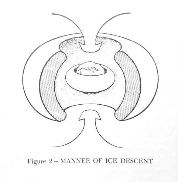
It would appear that as the earth was engulfed in this gravitational-magnetic catastrophic crisis, either (1) the astral visitor possessed an icy satellite which hit Roche's Limit and fragmentized, or possibly (2) it contained icy rings which were captured (or grabbed) by the earth's superior gravity. The first possibility is the more likely of the two. Roche's Limit for the earth is about ten thousand miles, a location well beyond the ionosphere, and in the magnetosphere.
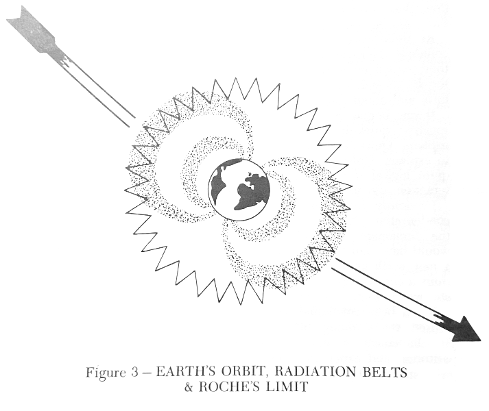
If such an icy body approached to Roche's Limit, it would fragmentize. The fragments would assume orbits around the earth in response to Kepler's laws, the principles which govern the orbits of man-made satellites.
The strength of the sun's short-wave radiation in the earth's region is very great. And the cold icy particles may be considered as a good dielectric, containing properties, like rubber, of being able to maintain a charge on one side of a particle without dispersing it throughout the particle. Thus, from the short-wave solar energy, an ice particle would pick up a charge.
Relative to rubber, a dielectric, and hair, also a dielectric, one may very easily rearrange the geography of one's hair without even touching it with his comb, providing there are charges of static electricity located on it. Hair will respond to the micro fields and will shift in location.
Similarly, it is suspected, the ice particles which shattered in the earth's magnetosphere, in the range of Roche's Limit, proceeded to pick up a charge from the solar radiation, and the particles were thereby defected by the magnetic field. Whatever their declination, they orbited around the magnetic poles in patterns something like longitudes, which all merge at the geographic pole.
As these particles shunted around the earth, they tended to collide in the region over the magnetic poles, and in their collisions, they tended to decelerate, and thus descend. Thus we hold that the Ice Epoch was sudden in its approach, magnetic in its pattern, and about five thousand years ago in its timing.
If one begins to view earth history from the catastrophic perspective, quick-drowned mammoths are really not too difficult to explain. Quick-frozen mammoths are also not particularly difficult to explain. Uplifted mountain chains, in great circle patterns, are quite logical if viewed from the perspective of gravitational interaction and internal tides on a rotating sphere.
Obviously, intruding ice particles serve as the perfect nuclei of condensation; hence an antediluvian canopy, the waters above the firmament, just might have been condensed out. They would have had to have been condensed out, setting the stage for a new earth climatology, a climatology based on heat disequilibrium, a climatology featuring deserts, monsoons, tundras, hurricanes, etc. which were unknown in the earlier climatic regime.
It has been concluded that the Ice Epoch may well have been caused by a dump of celestial ice in the magnetic region. Simultaneously, it may well be that some ice came in in lower latitudes, and experienced more friction, and fell in the form of rain, and rain by the buckets.
Thus, while we should look at the Flood crisis in terms of 150 days and nights of gravitational conflict, we should also look at the Ice Epoch phase in terms of something like forty days and forty nights of atmospheric intrusion, and obviously the first forty days and nights, until the reservoir of ice was gone.
Today we occasionally experience sunspots, and resultant magnetic storms, and ethereal auroras in all of their celestial brilliance. The Ice Epoch dump and the auroras have, geographically, an associative relationship. Both are related to the earth's magnetic field.
Thus, in beginning to understand the panorama of catastrophism in earth history, one wonders how the uniformitarian myth could achieve respectability, much less a monopoly in this twentieth century. This certainly must be rated as one of the great jokes of history, the uniformitarian myth in this presumed age of reason. One might reject uniformitarianism, and such associated views as atheism and Darwinism. But one can do much better than this.
We may begin perhaps to peer back to the Flood, and then through the Flood into the antediluvian era. We may begin to understand why it had a finer climatology, a greater longevity, and a more handsome and impressive fauna (animal kingdom).
And beyond this, one may begin to apprehend and appreciate the magnitude of creation, and the majesty of creation. We glean from the Psalms that the stars, those blast furnaces of the galaxy, are merely the finger-work of God; yet we read that He "upholdeth the righteous" (Psalm 37:17) by the "strength of His arms" (Psalm 20:6, Isaiah 62:8). We note that here, on the earth, on a speck in the universe, one finds this magnificent creation. We note that complexity more than size is miraculous, and what is more complex than man, formed in the image of God?
We are not evolved animals, we are a created race, and though fallen, are nevertheless the finest of a fine creation. For the sake of brevity, rather than consider the majesty of creation further, we may do well to return to the Book of Job. We may view the stricken Job, the righteous, smitten with pain, the objective of Satanic wrath, the heir of eternity, and may we ask, like Job something like this:
Can we "speak to the earth" and anticipate that it will teach us well?"Out of whose womb came the ice?
and the hoary frost of heaven, who hath gendered it?"
Job 38:29
"Knowest thou the ordinances of heaven?
Canst thou set the dominion thereof in the earth?"
Job 38:33
For further information or to contact Baker Books regarding their other fine publications, click below:

Go to "A Symposium on Creation" Vols. 1-6 Go to Main Page of: www.creationism.org