 |
|
|
Chapter 2 · Catastrophe:
The Geology of the Region
Coastlines before
It is hard to work out the exact geology of the pre flood era. Many of the original rocks are either covered by sedimentary or igneous formations, or have been metamorphosed during the flood. Looking at the sedimentary rocks, which are not igneous intrusions, especially those carrying fossils we can get a fair idea of what the terrain looked like. It seems that there were no deserts or harsh landscapes. There were no precipitous mountains and frightening gorges. The soils were well balanced and constituted a variety of different coloured sandstones, quartz and jaspers. There were probably mountains, rivers and lakes with a well-designed drainage system to the sea.
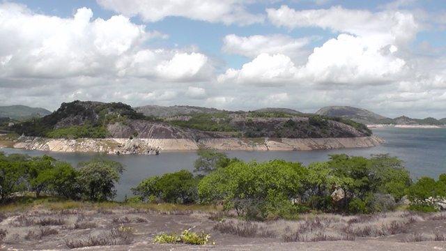
Zimbabwe's Kyle National Park; showing granite hills |
The rocks deep down under the sandstones may have included some granite. The countryside would have been gentler and higher areas would not have had the steep gradients we now see at high altitudes. The coastline was different from that seen today. Most of Mozambique was under water with the coastline stretching along the east of the Lebombo to Pafuri, to Beira up to Sinja. Zimbabweans would have had their own beaches in Gona re Zhou. The coast may have jutted out a bit in the vicinity of East London and parts of the West Coast. God designed everything for mans’ comfort, benefit and pleasure, but this countryside was to change when the torrents of rain fell out of the sky. |
Comets
Where did all the rain come from to last 40 days and 40 nights? An estimated 24 000 meteoroids – each weighing more than 3.5 ounces – strike the earth annually. Meteoroids are made up of stone and/or iron. A good example of a meteorite is the Hoba farm meteorite 25 kilometres from Grootfontein in Namibia. This is the world’s largest meteorite and weighs approximately 54 tonnes. Comets including the famous Halley’s Comet contain large amounts of water in the form of ice. Meteorites and icy comets could have hit the earth releasing large amounts of water and in some case leaving large craters. They could have produced powerful gravitational forces, earthquakes, volcanic eruptions, giant tidal waves, spin axis shifts and other nasty effects on the earth.
Mammoths found in the Northern Hemisphere support the theory of icy comets. They have been found frozen with plant material still in their mouths, meaning that they were killed almost immediately and covered by snow. Over 116 large impact sites have been found that were created or most likely to have been created by meteorites or comets. Most of these crater sites are found in Western Europe, the USA and Australia. Five of these craters are 76km-140km in size, including the 87- mile wide Vredefort dome in South Africa. Just one of these five larger crater sites may have had a collision capable of destroying a large part of the life on earth. The Lake Acraman impact crater in Australia has a 56-mile diameter. It was estimated that the energy released in this impact would probably have been the same as 50 000 to 100 000 hydrogen bombs going off all at once.
Most of these impact craters were not formed in recent historical times
and probably fell at the same time during the flood. The combined
affects of all these meteorites and comets would have been enough to
have started flooding, bringing the rain, tidal waves and ruptures in the
earth causing volcanic activity.
Water Beneath
Recent research has uncovered deep-sea vents, which release water
from under the earth. We don’t really know how much water there is
under the ground. This underground source could have been one of the
water sources during the flood and mentioned in the Bible. The
underground waters could have been released as the ground developed
fractures due to the rising sea.
Sedimentation
If you place soil and water in a glass and shake it, you will find when it settles, that the heavier material settles at the bottom and the lighter towards the top. This is the law of gravity at work. Clays often settle together, while vegetable matter may bunch up and float. Some of the floating vegetation will eventually sink.
The flood deposited sediments in much the same way. This is why in Southern Africa and other parts of the world there are heavy boulder beds, conglomerates, shale, ironstones, clays, sandstone, coals etc. 99% of sedimentary rocks in Southern Africa show evidence of having been deposited by a large body of water. In the Molteno sediments in the vicinity of Lesotho there are coarse-grained grey/buff sediments with well-preserved plants and insects to the virtual exclusion of body fossils. The finer grained red beds in the Elliot area nearby, yield abundant well-preserved body fossils, but not much in the way of plants. This pattern of exclusivity of plant and/or body fossils in certain types of sedimentary rock is common in the fossil record. It has been noted in the Zambezi valley and all over the world. This is a mystery to evolutionists but is easily explained by our simple experiment with the glass.
If fossil deposits took place over millions of years, plants would have
been deposited with the vertebrates in the same rocks on a regular basis.
Palynology
Sedimentary rocks in Southern Africa show no evidence of having been
laid down over millions of years. Rather, they show sediment forming
rapidly over a short period of time. Palynology is the study of pollen,
spores and their dispersal. These plant microfossils called miospores are
smaller than 0.2mm in size. In the Sebungwe district in Northern
Zimbabwe a borehole was drilled to a depth of 1200 feet. It was found
that the miospores were of the same mixture all the way through the
sediments, showing an unbroken sequence of sedimentation upwards.
This is would not be the case if the rocks were formed over millions of
years and rather shows a deposit created in a short time, such as during
Noah’s flood.
Physics Laws
For every action there is an equal and opposite reaction – a physical law
taught in school. This means that for all the geological formations we
see there had to be a ‘cause’ that formed them. With the removal of this
force we have a pretty stable Southern Africa today. What was that
force that doesn’t react on the landmass today? Why don’t we have
earthquakes and volcanic activity in areas that had so much in the past?
Earthquakes
Well as the floodwaters rose they covered the highest mountains to a depth of 6 metres. With this depth of water tremendous forces were unleashed which altered the geology and geography of the earth. Cracks developed in the continents, magma oozed up and there were volcanic eruptions. Tremendous earthquakes shook everything. Seismic activity has been measured in Zimbabwe since 1959. The areas that have produced earthquakes of 5 or more in magnitude include Kariba and Hwange.
Kariba is particularly unstable due to the volume of water in the dam.
Hwange has much mining activity and is fairly close to Kariba,
explaining the earthquakes there. Very little earthquake activity takes
place in other parts of the country, although mining sometimes causes
earthquake activity. If these pressures and disturbances cause
earthquakes, how much more would the Flood have caused ruptures in
the earth’s crust and frightening earthquakes? The floodwaters moved
large masses of sedimentary rock in awesome mudslides and deposited
the rock causing further instability. Some of these sedimentary deposits
are as much as three kilometres deep. Rivers overflowed their banks
and caused terrible flooding. The amount of suspended matter passing
the Orange River station in recent times has been computed at 50
million tonnes in an average year. At this rate in 1500 years the
Southern Africa land surface could be lowered by 30 cm. This modern
erosion is nothing compared to that unleashed in the flood.
Rising Seas
The rising seas killed the coral reefs, shellfish and other sea creatures
that couldn’t swim away. There were strong tidal activities and ocean
currents caused further destruction. Since the floodwaters have now
subsided there is now little pressure on the surface and less instability.
Occasional earthquakes and plenty of hot springs, such as those in
Northern Zimbabwe and parts of South Africa, are all that is left of the
volcanism of that period. One of the many towns in the region that has
benefited from the presence of hot springs is Windhoek, which has used
hot springs as a water supply. With the sea levels rising at present, we
may see more activity that is volcanic in the near future.
Volcanics
With the large volumes of water covering the land, the instability caused volcanic activity resulting in the formation of dykes, lava flows and cracks in the earth’s crust. Igneous rocks formed at the same time as the sedimentary rocks were being deposited.
Volcanoes formed such as the Messum crater in Namibia, found about 50km west of the Brandberg. This crater has a 20-kilometre diameter. In Southern Namibia there is a 2 kilometre wide volcanic crater called Brukkaros. The Ongeluk volcanoes of the Transvaal and Griqualand West were formed under water, as denoted by the pillow structures with chert filling between the pillows. The 500 square kilometres Pilanesberg National Park protects a complex of volcanoes and the famous Sun City gambling resort. Volcanic vents or diatremes filled with lava agglomerate, or tuff, have been found in the hundreds in South Africa and Lesotho. Agglomerate is a mass of large volcanic fragments bonded together by heat, while tuff is consolidated volcanic ash. Most volcanic pipes were perforations in the earth’s crust and seemed to have only produced gas. Lava, such as that found at Montaux- sources is about 4500 feet in thickness. These basaltic volcanics are found up to an altitude of 10000 feet.
Sandstone sediments were
deposited as lava poured out of these pipes. Some volcanic necks are
fairly large and many cover over 100 yards in diameter and can reach a
mile wide. Some of the volcanic necks are circular and some elongated.
The great Moderfontein volcano near Jamestown covers an area of 5
square miles and is filled with agglomerate. The area of eruption
around Roodepoort and Swartfontein is 8 miles long. The Belmore
volcano near Barkly East had sedimentation forming as the volcano was
erupting. At Tent Kop in Maclear, lava and ashes were ejected before
the deposition of the sandstone. Sandstones were washed into volcanic
necks, while ash and volcanic bombs ended up in the sandstone
showing simultaneous formations. Some of the lava flows in this area
covered one or two hundred square miles. As the lavas poured out very
little time took place between the flows showing a rapid formation. The
large amount of water sedimentation associated with volcanic activity
shows that these volcanics were formed during the time of the flood.
Diamonds
Igneous and metamorphic processes that formed many of our minerals accompanied the formation of volcanoes and lava flows. Tsumeb in Northern Namibia has produced 184 different minerals, 10 of which have not been found anywhere else in the world. The diamond you see sparkling on a woman’s finger was most likely formed during the flood. The source rock of most diamonds is a bluish ground called Kimberlite, named after Kimberly in South Africa. Kimberlites are found in Botswana, South Africa and Zimbabwe in Southern Africa. Kimberlites are rich in carbon dioxide and water. Industrial diamonds can be formed at high temperatures and at a pressure of about 90 K bars.
Volcanic activity accompanied by water, carbon containing sediment and the pressure of the Flood Sea, provided perfect conditions for the formation of diamonds. Carbon was formed during the flood as a sedimentary deposit in various rocks. The Flood Sea explains the brecciation of much of the kimberlite and the sedimentary material associated with some of these kimberlites. Fossils have been found with the Orapa and South African deposits, showing the kimberlites formed recently. Southern Africa is famous for its diamond deposits. Kimberly in South Africa was one of the prime sources of wealth in the Victorian era and helped finance the development of this region. Diamonds were found here in 1871 and soon there were 50 000 miners working away on the site.
The result was the biggest man made hole in the world dug without large machines. The hole is 180 metres deep. About 14.5 million carats of this precious rock have been recovered from that site. The famous Cullinan diamond was found at the Premier mine near Pretoria in 1905. The Orapa, Jwaneng and Letlhakane mines south of the Makgadikgadi Pans and near Gaborone, produce about 85 % of Botswana’s exports. In 1925 a young soldier found an attractive stone near Port Nolloth, which is close to the Orange River mouth. As diamond fever gripped the many miners who came here, the South African government and De Beers mining took control.
Areas on either side of the Orange River and along the coast became no
go areas reserved for diamond mining. Diamonds had been washed
down the Orange and Vaal Rivers, with some reaching the sea to be
deposited along the coastline. Some deposits were washed inland, as the
ocean was higher during and soon after the flood. Diamonds are mined
offshore using suction devices and dredges, while those on land are dug
out of the sands. From the Orange River there is a decrease in the mean
size of the diamonds both north and south along the coast. These
deposits show that the Orange largely brought down the diamonds,
from Kimberlite sources in the interior.
Greenstones
The greenstones are basic lavas that cover a large part of Zimbabwe.
The greenstones contain amygdaloidal and pillow structures with water
laid-down sedimentary rocks. The sedimentary rocks include
agglomerates, tuffs, arkoses, greywackes, cherts, banded ironstones,
slates and limestones. Algal structures have been recorded to the north
of Bulawayo in limestones carrying graphite and they were situated
well down in the greenstones. The pillow structures in the greenstone
rocks point to a sub aqueous and submarine eruption. These green
stones are often regarded as being some of the oldest rocks around, but
it is clear that they erupted under the floodwaters.
Granites
The granites of Southern Africa are thought to be millions of years old because they do not have many fossils associated with them. According to evolutionary theory, rocks that have no fossils would have formed before life started to evolve. However, igneous rocks in their formation are unlikely to trap fossils due to their heat, so these are mistakenly labelled as the first rocks. The high temperatures around these rocks as they formed during the flood would have destroyed any fossils, so the lack of fossils does not imply great age.
In fact, if these rocks have been around longer than the other rocks, then they should have fossils of many different ‘ages’ nearby. As this is not the case, the idea that these rocks are so old is laughable. A method used to date igneous rocks is the faulty radiometric dating system. These often give very old readings that ‘make’ the rocks appear older than they really are. The Hualalei lava flow in Hawaii was dated using the Potassium-Argon method to between 400,000 years to 3.3 billion years old. This is acceptable to those who believe in evolution. The problem with this reading was that the lava flow was less than 100 years old. Similar readings have been obtained from other young lavas. This shows the unreliability and poor science involved in dating rocks with radiometric dating techniques. The use of some of these radiometricdating techniques can be likened to using a 30-cm ruler and marking each centimetre as a kilometre. Zimbabwe probably has the best granite formations in Southern Africa, as they stretch across a large part of the country.
In the Matobo hills there are plenty of conglomerates mixed in
and around the hills, with much of the material having been derived
from these same rocks. In some valleys, there are giant boulders that
could only have been moved by an incredible power. The fragmentary
nature and different crystal structures of the granites that were exposed
to water resulted in the strange rock formations we now see today. The
Matopos has strange orbicular granite formations that are a mystery to
geologists. These were most likely to have fashioned as the granite
formed under water. Much of the granite in Zimbabwe, the Cape and
Swaziland are intrusive into other rocks, including sedimentary rocks,
showing they were formed during the flood. The presence of
greenstones and sedimentary rocks show granites were formed in
association with water.
Basalt
Basalt is another common hard rock found in Southern Africa, much of
it having been formed under water. In Lesotho, the Cape, Swaziland,
Lebombo Mountains, Springbok flats, Soutpansberg, Kalahari region
and parts of Namibia are found extensive basalt deposits. There is a
marked absence of sediments and weathered horizons between the lava
flows. A borehole drilled at Victoria Falls to 152 metres was found to
have no sediments between the flows and no evidence of weathering
before the next flow formed. Rocks called zeolites present around the
Victoria Falls gorges are some of the rocks showing these basalts formed
under water. The Zambezi valley had a lot of Basalt mixed in with
water deposited sandstones. Pillow structures found in the basalt at
Kariba and parts of Matabeleland shows that these rocks formed under
water. At Kariba, a dinosaur was found associated with pillow lava and
water laid down sediments. Basalt rocks North of Bulawayo are found
with shale and sandstone between the flows. The alternating basalt and
thin sandstone are further evidence for the formation of these rocks
during the flood. Similar alternating deposits have been found
elsewhere in the region. All of this shows that Basalts were formed
rapidly, with sandstone sometimes being washed in between the lava
flows by the floodwaters.
Dykes
Another widespread rock is dolerite. The dolerite dykes of the Karroo were formed during the flood period. Like many of the Basalts, the flows took place soon after each other, following each other rapidly and freely. This is shown by the upper surfaces of previous flows not being exposed for long before a new sheet covered it. A sheet of dolerite North of Hopetown covered approximately 13000 square kilometers. The Great Dyke in Central Zimbabwe is said to be the longest linear mass of rock of its type in the world. This dyke runs roughly 530 kilometres and can reach a width of 11 kilometres. Other intrusive dykes and faults parallel the Great Dyke.
The Great Dyke is a source of valuable platinum and chrome reserves. The pressure on the land surface by the Flood Sea caused this dyke and those faults nearby. The Great Dyke was strongly weathered as it formed under the sea. All this evidence indicates that the volcanic activity, granites, basalts, dolerites and other igneous rocks were formed very quickly, in association with water and occasionally fossil formations. The Flood Sea had all the necessary ingredients to cause this and is the best fitting explanation for their formation.
| Current
Flow
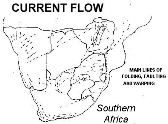
There is much evidence to show that when the floodwaters had reached the maximum height, the currents flowed in a general North South direction with few exceptions. This is independent of the type of sedimentary rock or its depth. The exceptions are explained by tidal and river activity, during and after flooding. In some areas of Botswana and Zimbabwe, the directions were slightly different. If there was an ocean covering Southern Africa during the flood, we should have evidence for the movement of ocean currents across the sub continent. The striated marks on rocks, the dune formations and rock foldings, all show the current directions during this period. |
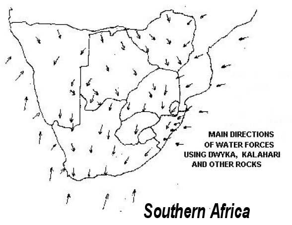 |
One of the best indicators of the flood current flow is found in the Dwyka or boulder beds, found in parts of Southern Africa. Flood currents have made marks on rocks from the Cape up to the Congo. This shows us the general flow of the Flood Sea at the height of the Deluge. It also explains why we have so much sediment on the Agulhas bank. The continental shelf is from 30 to 45 miles wide on the Atlantic side, but reaches a 150-mile width on the Southern Agulhas bank. There is a rough sketch to show how the main foldings, fractures and faults of Southern African rocks tie in with the flow marks in the rocks. This is probably one of the strongest evidences for the flood in the sub region and helps explain so much of our geology.
 |
Dwyka
The boulder beds of the Cape Province of South Africa are called the Dwyka and are bluish or greenish in colour, being compacted and fine grained from water action. They contain sand, pebbles and boulders of a great variety of rocks, the majority are recognised as conglomerates, quartzite, sandstone, shale, slates, crystalline limestone, jaspers, banded ironstones, granites, gneiss, diabase and amygdaloidal lava, quartz porphyries, serpentines etc. The smallest fragments are commonly angular and larger ones show some rubbing off the corners. Some specimens reach 10 feet in diameter, though most are normally smaller. Some of these were transported hundreds of miles. The boulders are scattered in the matrix without orientation and in some cases, they are arranged in well-defined layers. Similar large rocks are found in other parts of Southern Africa and have been given this same Dwyka name. Many people have been mistaken in thinking that glaciers formed these large rocks. The only water forces that could have moved rocks of this size are the forces of glaciers, ocean currents or very big rivers. To say it was a sea that caused these formations would be admitting there was a worldwide flood, so glacial processes are often accepted in the scientific community for much of the activity. Research has found that so-called glacial deposits in the Coeriesfontein and Vryburg areas were created in a sub aqueous state. |
Geologists have found that the so-called Dwyka shale associated with the boulders, in some areas accumulated under marine or estuarine like conditions. Boulders of the Dwyka have arkose with a content of kaolin, which are unlikely to have been deposited in a glacial formation. In the Southern Karroo, intercalated varves occur within the deposits at Douglas and in the valleys of the Northern Karroo. These varves probably accumulated in fresh water. The development of varves is apparently inhibited by saline conditions, due to the flocculation of clay particles. The Flood Sea would have had more fresh water in it. The deposits though often show no definite marine or freshwater formation, which ties in well with Noah’s flood. These boulder beds contain coal bands and plant remains.
Plants in Glaciers
Plants found in so-called glacial deposits include carbonised plant stems
and a frond wedged in between boulders of rhyolite near Strydenberg.
At Matjiesfontein plant specimens were found in pseudo boulders of
quartzite. Plants were also found on the Riet River near Kimberly in
shale, which contained large boulders. These plant remains in the
deposits make it very unlikely that glaciers deposited these rocks. Fossil
tree trunks have been found in Dwyka deposits. The tropical nature of a
large part of Southern and Central Africa makes it unlikely that glaciers
ever existed here. In South Africa the Dwyka shales contain the fish
Palaeoniscus capensis and the aquatic reptile Mososaurus. The shale
may contain from 12 to 14 % carbonaceous matter, including
hydrocarbons and some oil can sometimes be produced. This shows a
large amount of living matter was deposited with the boulder beds. The
few marine fossils from the inland of Southern Africa shows that the sea
covered the land for a short period of time and this is supported by a
mix of both salt and fresh water types. Marine fossils in the Dwyka
boulder beds kill the theory of an ice formation for these rocks.
Rocks moved
The rock floors, on which the boulder beds rest, are often polished and finely striated, showing the force that moved them. Some of these boulder beds reach a thickness of 600 metres. Many of the rocks were striated or scratched as the sea currents forced them along. Some were flattened or faceted from this and the water pressure. Beautiful striated surfaces are to be found on lavas at Pniel, Douglas and Riverton. From the many striated pavements, it is easy to see the direction of the current flows. This and the inclusion of rocks carried by the current and the knowledge of their origins all help. Some rocks were carried 800 miles. Rocks from the Transvaal can be found at Barkly West and Hopetown. Griquatown jaspers and Matsap conglomerate are found in parts of Namibia and the Western and South Western Karroo. They are not found anywhere to the south or south east of Griqualand west.
A good place to see the boulders still resting on the striated rock
surfaces is at Nooitgedacht near Riverton in the Kimberly district. At
Tafelberg on the Palala River the coal measure grits rise from a pedestal
of granite and where these rocks join, the contact discloses a striated
surface directed south 30 degrees west. Coal formed in this striated
surface and coal would never be found in a glacier. Glaciers go in the
direction gravity takes them. A large glacier heading in a general
southerly direction didn’t cover the whole of Southern Africa, from
tropical Angola down to the Cape, nor were there many small glaciers
going in the same direction. The glacial theory is not logical and does
not explain things very well. Rather what has happened is that powerful
ocean currents of the Flood Sea dragged rocks over rock bases and
formed the scouring marks.
Fish River
The mighty Fish River Canyon in Namibia is regarded as one of the
world’s natural wonders. It is said to be second only to the USA’s Grand
Canyon in size. It is 160 km long, 30 km wide and 550 m deep. The
violent waters of the flood had sufficient force to carve out this Canyon.
Marked Rocks
Some other examples of current marked rocks include: From Zululand to Transkei strips of marine sediments bent down on the southern seaward side indicating a southern flowing current. In Natal, coarse sandstone in the Vryheid area seems to have come from a northeast origin. In Natal, the planes of some rocks dip west or southwest suggesting that the source of the detritus was situated to the east of Zululand. The rock foldings of the Cape and Drakensberg mountains show by their contortions to have been formed while wet, by a current coming from a general Northerly direction. In the Cape the sandstone as a whole becomes finer in grain towards the south, the pebbles smaller and fewer with thinner bands of shale in the south.
The Cape Mountains have their largest pebbles in the conglomerates in both the northwest and northeast. The sediments contain jaspers that can be matched with those of the Northern Cape, Vryheid and Zululand. The foldings in the Natal and Cape show the current flow took the sediments in the direction of the Cape. The Bokkeveld shales of the Cape contain blue-grey muds that were laid down in water. The sediment gets finer to the south indicating a northerly source. There is no doubt that the Bokkeveld beds were deposited in the ocean as is shown by the marine fossils and flow marks in the rocks. The Witteberg rocks like others of the Cape get finer as they go south. The Cape sedimentary rocks are folded with a generally south facing wedge.
In
the Swellendam Heidelberg basin and in the Oudtshoorn area the dips
are almost universally northwards from 10 degrees to 25 degrees and
near Uniondale at angles of 45 degrees. Southerly inclines of up to 50
degrees are to be found in the Cape. Nearly all the sedimentary rocks in
this area seem to have a Northerly origin. Huge gouges were taken out
of the Cape Mountains by waters flowing south, enabling rivers formed
on the north side of the mountains to flow into the southern ocean. All
the important rivers of the Cape mountain system such as the Gourits,
Gamtoos, Sundays, Fish and Kei originate in the interior region behind
the mountains and flow south through the mountains, through deep
gorges to the sea, defying meteorological and geological barriers.
All carried by Flood Sea
In the Western Cape at Saldanha, rocks were most likely to have come from a Northerly direction. The quartz porphyry and grey granite may have come from a site 8 kilometres to the Northwest. Lydianite, hornfels, dark blue quartzite and flagstones may have come from Saint Helena bay 32 kilometres to the Northwest, while white, blue grey and reddish quartzite could have come from Piketberg 40 kilometres to the northeast, across from the valley of the lower Great Berg River. These deposits were not beach or river deposits.
Some of the rocks had been transported to positions higher than their
source areas. Only the powerful floodwaters could have done this. A
current moving from the northeast to southwest deposited the fossils
deposited in this area. Near Niewoudtville, scratched marks on rock
surfaces are found aligned in a direction of South 57 degrees east. Jasper
gravels found south of the Orange River originate from the Griquatown
and Doornberg hills. These rocks are found in the Hopetown area at
3600 feet and were transported here from about 70 miles to the north.
Small fragments are found near Hopetown and Britstown up to
altitudes of nearly 4 000 feet. These rocks would have had to have gone
downhill and then up again. The flood best explains this geology, as
only powerful ocean currents could have taken these rocks uphill. The
pebbles become gradually smaller as one goes further to the Southeast.
Mariental and Bushmanland have scratched rock floors showing the
sediments originated from the north. In Namibia, sediments along the
South side of the Windhoek highlands show considerable folding. The
trends are northeast to Southwest. In the Great and Little Karas
Mountains, we find scraped surfaces showing a general north south
direction. You may have been bored with all this, but the geology
plainly shows there were ocean currents and they had specific
directions of flow.
Gauteng Gold
The Transvaal sedimentary deposits contain boulder beds;
conglomerates, pebbles, grits, sandstone and clays all deposited by
water. These deposits came from a general northerly location, as is seen
from the marks on the rocks and the sediment content. The sediments of
the Witwatersrand reach many thousands of metres thick and were
moved south by the flood ocean currents. In this area, sedimentary
rocks in some places are characteristically contorted. The lack of pattern
in these contortions, with no affect on the strata above and below,
means that these are not tectonic features.
Ferricrete
Ferricrete in compact beds up to several feet in thickness are found in
various parts of South Africa. These consist of a large proportion of clay,
sand and angular fragments of quartz or other material, cemented
together by hydrated oxides of iron. The Transvaal sediments include
water laid down banded ironstone with silica rich sediments, some
being rich in soda. These ferruginous rocks require specialised
conditions such as a basin or large body of water, with certain oxidising
conditions. The flood provided for these conditions.
Kalahari
Sands & Victoria Falls
The Kalahari sand formations show the current flow of the flood better
than many rock formations. Large parts of Southern Africa were swept
by flood currents and left behind undulating dunes, which we call
Kalahari sand. When the floodwaters subsided, the Cubango, Cuando
and Upper-Zambezi systems were left to flow along the same routes
that the currents had taken. This explains why the Okavango formed
and why the water never reached the Ocean.
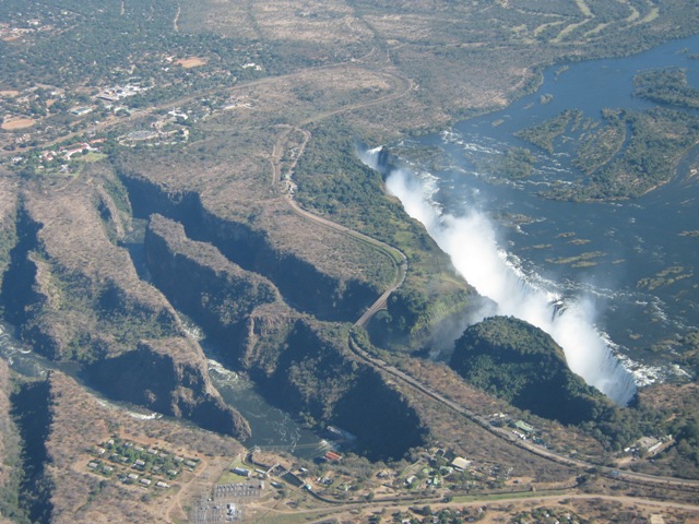
The
Victoria Falls area has three main sections. These sections are the Upper
Zambezi, Victoria Falls with zigzag gorges
and the long 80 kilometres or so Batoka gorge system. The Batoka gorge
is surrounded by some of the roughest country in Southern Africa. You
can easily see that a huge volume of water gauged out the rough terrain
covering this country and the Batoka gorge. There seems to have been
no gradual erosion causing the water to cut through the gorges neatly
and it appears most of the erosion took place violently under the sea.
The Batoka gorge 60 kilometres down river from the falls is no more
eroded than the gorge 10 kilometres down river from the falls. This
should not be the case if they are millions of years old. The beautiful
Masuie Falls a few kilometres down from the falls would have cut back
a lot further if it had been flowing there for millions of years. Closer to
the falls there are zigzagged gorges that are very different and would
have been formed by a slower erosion process since the flood. Above
the falls all the way to Kazungula on either side of the river, huge
Kalahari sand dunes were formed by the floodwaters. Some of the sand
was washed into dunes downstream of the falls. These dunes often have
an alignment of 90 degrees to the present river. Some of these dunes are
more than 100 metres higher than the surrounding country. Good
examples of this are those sand areas found on either side of the river
close to the falls. These dunes were formed by powerful water activity.
The Zambezi drained a large part of Northern Botswana’s ‘puddle’ that
was left over from the flood. Victoria Falls and the Batoka gorge system
were made in a very short period of time and not in millions of years.
Kalahari
sands their makeup
The Kalahari sands were deposited by water, the top sections may have
been windblown in places since the flood, but the lower sections show
definite water deposition. The sands vary from a red to grey colour. The
Kalahari sand begins at the Orange River just North of Upington and
spreads over the Kalahari Desert through parts of Namibia and
Zimbabwe, then into Angola and Zambia.
These sands are found in the Northwest Transvaal, north of Pretoria, the
lower Olifants valley, the coastal belt of the South West Cape, at
Kimberly and the Western Free State. Namibian sands have been found
with signs of water deposition as they had water laid down limestone or
calcrete formed by the flood. The Kalahari basin consists of various clay,
molluscs, calcareous marls, sands and gravel bands with overlying
sand. In the western Kalahari there is a fossil Calcium Carbonate
horizon of a vertisol-like soil. In the central Namib, a dark grey layer
contains organic carbon, charcoal, ash, fossilised plant and animal
matter, implying denser vegetation and higher rainfall.
The evidence
shows the Kalahari was never originally a desert and was devastated by
the flood to form the inhospitable environment we find today. Before
the flood, it was well watered and rich in vegetation. Linear dune ridges
in the North West of Zimbabwe are 0.5km to 2.5km apart and up to
120m high and can stretch unbroken for many tens of kilometres. These
dunes have many similarities to the dunes found in Botswana and have
mud flats associated with them. The grain size of the sand in Northwest
Zimbabwe rarely exceeds 1mm in size and ranges from 0.15mm to
0.4mm. The particles are not well rounded or sorted. Clays are often
found between the dunes in Zimbabwe, which are most likely to have
been deposited by water. In today’s active desert dune fields, the
combined silt and clay content are normally very low and do not exceed
5% of the total sediment. In the Zimbabwe Kalahari sands, these figures
are exceeded and this contradicts desert deposition theories.
If you fly
over the dunes, you will see that a current seemed to flow in a general
Northwest to Southeast direction. Evolutionist claim winds were the
sole cause of the kalahari sands. Only impossibly powerful winds could
have made anything similar to the dune formations we now have. The
wind direction would have been different from that of today’s winds, to
form the alignments of these dunes. To support the ocean current theory
we have many non Kalahari sand rock hills in Central Namibia
stretching across to the Okavango, aligned in the same direction with
the dunes and these couldn’t have been made by a wind. To the south of
the Kalahari, many of the hills around Kuruman and north of the
Orange have the same alignment with the sands. In the Lake Ngami
area grey, yellow, red and violet crystalline limestones alternate with
calcareous shales and sandstones. The strata of these rocks are dipped
southeastwards at moderate angles. The same sort of direction the sand
dunes are directed. Minerals such as Kyanite, garnet, epidote,
sillimanite and andulisite show the Kalahari sands came from a general
northwest direction.
Large
Pans
During the flood, some areas were eroded to flat surfaces or into pan
country. The Flood formed the 75-mile long Etosha pan in Namibia,
while in Botswana the famous Okavango and the pans of Makgadikgadi
were the result. The 15000 square kilometre Okavango Delta is one of
the worlds largest inland Deltas and probably the most dramatic. Inland
pans are found from North Calvinia through Britsown and west of the
Free State, with an arm stretching through Gordonia towards Gibeon.
Most of these pans are circular or oval but they may be irregular in
shape. Some are many miles in width such as Haakshein Vlei and
Koppies Kraal pans found in Gordonia, which are 14 miles by 6 miles
and 9 miles by 5 miles respectively. Government’s pan in Strydenberg is
16 miles by 2 miles in size. Many pans are found in the Transvaal. Some
of these pans are many miles in diameter. These are fresh water pans in
contrast to the saline Cape pans. Lake Chrissie is a water body that has a
length of 6 miles and is surrounded by hundreds of smaller pans, in an
area of about 740 square kilometres. Pans are found in the Marico
district and on the Kaap plateau. All these pans have bases of water laid
down sedimentary rocks, showing they were originally formed by
water. Most pan depressions are only slightly below the surrounding
country, though a few are as much as 200 feet beneath the surrounding
country.
Krans, Vogelstruis and Vogel pans in the Hopetown area are sunk
abruptly, with the Northwest rim in each case being cliff capped with
calcareous tufa that covers the surrounding countryside. The Kalahari
sand areas have thousands of small pans littered between the sands and
dunes. Many of the depressions in the northern Kalahari were formed
in water drainage lines. An area of light coloured sand, which
sometimes forms dunes, bound the southern and southeastern sides of
many pans. An example of this is Salt Lake between Belmont and
Douglas. These may be from wind action taking place since the flood.
The 12000 square kilometres Makgadikgadi depression is covered with
a greenish, siliceous saline crust and once covered 80000 square
kilometres. After the flood, pans were left behind by the floodwaters
and have been progressively shrinking to this day. The reason for this is
that the catchment areas are too small to keep them full. The
Swartkolkvloer pan in the North West Cape is about 80 square
kilometres in size, compared to its previous size of 120 square
kilometres after the flood. This pan was linked to other pans that were
also larger. The Alexandersfontein pan near Kimberly at 19 metres
above its present level was 44 square kilometres in size and its
catchment was 390 square kilometres in size after the flood. Where did
all the water come from to fill these water bodies at their original size
and how did such large pans form by water? The flood explains this
drying puddle syndrome, which is not unique to Southern Africa, in
which lakes and pans have been drying up since the flood.
Limestone
We build our houses with cement and rock that were formed by the
floodwaters. Limestone is used to make cement and often has human or
animal remains in it. So we have all benefited from the misfortunes of
those dying in the flood. Dolomite prevails over the Transvaal,
Northern Free State, Griqualand West and Ovamboland. These areas
were covered with a deep, warm sea, which formed these rocks.
Much of the limestone in Southern Africa has turned into dolomite.
Some deposits had manganese in them recalling the modern deep-sea
oozes. Aragonite was directly precipitated from the calcium sulphate
contained in seawater by the action of ammonium carbonate from the
decomposition of living organisms. This aragonite was the material
from which dolomite and limestone were formed.
There is no doubt in
the minds of geologists that the dolomite in the Transvaal and Cape is a
marine deposit formed in the open sea away from land, but probably at
no great depth. The oolitic bands, conglomerates and ripple-marked
surfaces point to tidal activity. The Otavi dolomite is estimated to be
7000 to 10000 feet thick and has limestone in it. It is probably the
thickest of its type in the world. Sandstone and shale mixed in with it
shows it was water deposited. Dolomite normally replaces calcium
carbonate and this would take place in a tidal setting or just above the
high water mark. Chert may be also mixed in with the dolomite. The
siliceous skeletons of sponges and diatoms may have formed cherty
matter found in the limestones. Banded ironstone is also found with the
dolomite. This would indicate that the dolomite formed under a large
body of water. Some limestones and dolomites in Southern Africa are
called micrites and were formed in quieter water conditions; others
called oolites were formed in violent water. Both conditions were
present in the flood. The flood deposited coarse materials, leaves and
fossils into limestone breccias, making them ideal for fossil hunting.
Limestone is found in the Cape mountain ranges and this would have
formed from the tidal activity washing over these formations when the
sea was higher.
Stromatolites
With all the vegetation and animal matter in the Flood Sea, there was an
ideal environment for the build up of algae. When Lake Kariba filled
with water, the troublesome salvinia weed and blue-green algae formed
on parts of the lake. This same algal build up would have taken place during Noah’s flood.
When the floodwaters began to drop, they left these algal deposits on
the surface and these were mixed in with other rocks by tidal activity.
Stromatolite is the name given to these rocks containing blue-green
algae. They are abundant in Zimbabwe and found in the Transvaal,
Namibia and Northern Cape. These algal deposits are often thick and
may be mixed in with other sediments such as limestone and graphite.
Algal deposits of such size could only have been formed with a large
volume of water, with lots of nutrients in the water. Algal structures
found in Dolomite north of Kimberly were elongated and mound like,
measuring 10 metres across and 60 metres in length. These stromatolites
appear to have been formed by marine currents in a deep-water
environment, which may have been in a tidal area.
The mounds have an
East West elongation that would be at right angles to the shoreline. All
of this shows some of the Southern African dolomites were formed in
marine conditions. Limestone formations, such as the well-known
Cango caves of the Southern Cape and the remote Drotsky’s caves of
Botswana, have attractive stalactites and stalagmites. Most stalagmites
and stalactites grow slowly; giving the impression it took them many
millions of years to form. We know that cave formations formed in
tropical areas grow quicker than those formed in temperate regions. The
high rainfall of the tropics causes this difference. Some of these
formations would have grown faster with more water present after the
flood.
Clay
In Griqualand West and Botswana, fine mud was deposited by the deep
floodwaters. There is no break with the dolomite and chert below.
Similar muds, of the same reddish and bluish colour, are found in deep
parts of the ocean.
Shales in Zimbabwe, Malawi and South Africa were formed in deep
water and this is shown by the fineness of the grain, even stratification,
uniform dark blue or black colour and by phosphatic nodules carrying
fish remains in Natal. Kaolin clay is found amongst granites in
Zimbabwe and extensive deposits of other clays are found in other parts
of this country. Weathering or water processes, here and in other parts
of the region, could never have produced the thickness of these clays. A
large volume of water had to be involved.
Marine
Fossils
There should be very few marine fossils far inland, as the time period
was too short for the marine populations to establish themselves there.
That is why Zimbabwe and Botswana are almost devoid of marine
fossils. The seashell or marine fossil deposits show us where the
seacoast was before the flood. Around the coasts of Africa marine
deposits show that there was no continental drift as has been taught. If
plates were moving and new land was coming out of the Atlantic
Ocean, the African continent would be covered with ancient marine
sediments, but this is not the case.
There are obvious cracks in the
earth’s surface caused by the flood and tectonic activity, but no
movement like we see in some textbooks. There are a few isolated
marine sediments far inland in Southern Africa, which show that the
Flood Sea covered the land for a short time. There was though a mass
extinction of marine creatures during the flood along the coastlines.
How can we explain such densely packed fossil beds along the
coastlines? The reason why we have more shellfish fossils than fish
fossils in these deposits is that the fish coped with the flood scenario
better than the slow moving shellfish. Many of these shellfish died
rapidly and were never opened up by predators. Many marine species
became extinct during the flood due to the incredibly violent conditions.
At Conception Bay in Namibia a conglomerate with molluscs reaches
ten miles inland.
Zululand
At Port Durnford in Zululand, oysters, fishes, foraminifera and
mammal bones were found together with lignite. This shows how the
floodwaters mixed here, as elsewhere, a mixture of marine and
terrestrial sediments. Foraminifera are marine protozoans having a
perforated shell through which amoeba-like pseudopodia emerge. In
Zululand a brachiopod called Agulhasia has been found in sediments. A
brachiopod (lampshell) is a marine invertebrate having a ciliated
feeding arm and a two-valve shell. Agulhasia is normally found at
depths greater than 240 feet. A violent sea can explain the presence of
these creatures deposited so high up on land. In Zululand, the ocean
settled marine sediments at the base of the Lebombo, at Komatipoort
and also along the Limpopo. In Zululand, deposits reach a depth of
1830 metres. Coccoliths have been found in Zululand marine deposits,
which in other parts of the world form chalk. Many of the marine
sediments of the East Coast show a resemblance to living forms.
Coelacanth
The Coelacanth was presumed to have become extinct 80 million years
ago. It was regarded as a direct ancestor of humans. They suddenly
turned up off the Comoros in 1938 and more recently near South Africa
and in Indonesia. The find of this fish was mind boggling to
evolutionists and had the same affect on them as a dinosaur having
suddenly walked down the street. These fish can live at depths of 180m
and inhabit submarine caves. They can swim upside down or on their
heads and they bear live young. Fossils of this fish showed lobes, which
scientists mistook for the beginning of legs. This is why these fish were
thought to be the missing link between fish and land creatures.
Research has shown that this was nothing more than a scientific myth.
Only a serious flood could have killed these creatures and deposited
them in land sediments.
Cape
Marine Deposits
There is a uniformity of marine sediments in the Cape deposits showing
no evolutionary process. The Cape marine sediments are not found
more than 20 miles inland and are usually less than 10 miles from the
sea. These sediments are found up to 1200 feet above sea level and the
dunes and limestone in the area indicate the sea was higher. Those
deposits found between mountain ranges are normally on the seaside of
the mountains. The Cape marine sediments contain ammonites,
cephalopods, echinoids, brachiopods, ostracods and foraminifera (all
different types of shellfish and small sea creatures). Foraminifera are
tiny one-celled creatures. Their sensitive shells chemically record the
temperature and salinity of the water when they were alive. When they
reproduce they discard their shells which lie on the ocean floor, leaving
a record of past water conditions. Sedimentary samples taken from the
Gulf of Mexico showed that some time in the past there was a dramatic
drop in the salinity of the sea by 10%. This can only have been Noah’s
flood.
The
Cape
The Saldanha Bay area, covered in another section of the book has a
great variety of mixed marine and terrestrial sediments. The same
mixture of deposits is found around Port Elizabeth, where there are
thick marine deposits mixed in with terrestrial deposits. At Douglas
cephalopods, brachiopods, fish and fossil wood are found at the same
sites. The reason why there are marine deposits many kilometres inland
is easily explained by the strong tidal activities of Noah’s flood. As the
sea rose and then subsided a multitude of creatures were killed.
Sediments on the Agulhas bank and on the southwestern Cape were
dredged and showed phosphatic concretions, fish teeth, ear bones of
whales and shells. These show that much of the flood sediment lies in
the ocean.
Freshwater
Fish
Freshwater fishes living in our rivers in Southern Africa show there has
been a linkage between southerly and northerly water bodies. There is
evidence that northerly fishes somehow managed to go south. Did the
fishes somehow migrate across land? No! They did not because they
swim! However, the floodwaters covering Southern Africa enabled
migrations. In parts of the region, there are isolated pans or water
bodies with fish in. There is no explanation as to how these fish got
there. The beautiful killifishes are found in isolated pans such as those
of the Gona re Zhou and Beira area. How did viable populations
survive here if evolution is true and how did they get there? In
Namibia, the Guinas Tilapia and Cave Catfish are found in very isolated
water bodies with no evolutionary explanation as to how they got there.
These fish mysteries are easily explained by Noah’s flood. These fish
have relatives further north from which they could have been derived.
The floodwaters may have washed them south, or they may be the
remains of a once resident population that lived in a well-watered area
before the flood.
Coal
Every time we drive a car, we use fossil fuels derived from organisms
that died during Noah’s flood. We use coal for farming and for various
industrial purposes. Gas made in the flood keeps the braai-vleis burning
and many kitchens cooking. Coals in South Africa are found mostly east
of the 26th meridian and South Africa has produced up to 29 million
tonnes of coal a year. Coalfields are found in Natal up through to
Swaziland, the Transvaal then into the Free State. Many of the fields are
linked and cover an enormous area showing there was a large
deposition at the same time. These coalfields are found in Botswana,
around the Drakensberg, in Karroo deposits, extensively in Zimbabwe
and then down into Mozambique. Sediments of the Zambezi valley are
thousands of metres thick in places. They contain mudstones, sands,
grits, fine sands, siltstones, coals and fossils.
In some areas of the Zambezi Valley, pebbly arkose and shale are mixed
in with coal seams showing water was involved. The nature of the
sediments, show there was a quick deposition, violent in places and a
large amount of water involved. The sandstone mixed in with the
conglomerate shows that there were periods of high energy flooding.
Hwange
The Hwange coalfield can produce half a million tonnes a year and has
been mined for decades. Up to 1975, the Hwange coalfield had not
produced spores or pollens. This shows that it was not a peat formation,
but formed by a gravity sorting process in water. Other coals in the
region did have spores and pollens in them, but were also gravity
sorted. Plant remains and impressions have been found in the Hwange
coalfield. The coals of Zimbabwe often show a southwest to northeast
direction, which would tie in with the prevailing water currents at that
time.
South
Africa Coal
Coal seams in the South of Southern Africa are thick and reach more
than 150 to 300 feet. Coals in parts of Natal were deposited by currents,
which seem to have been going in a generally southwesterly direction,
indicative of ocean currents. Between Dundee and Ladysmith oval
ferruginous concretions, carrying fish remains are abundant in a thin
zone in the shales associated with the coal. Coal seams at Witbank
include boulders showing they were formed in a violent environment.
Glauconite is associated with coals in South Africa and this shows a
large water deposition. Some marine fossils were found in South
African coals. These include a sponge, a cephalopod and acritarchs. On
the Zululand coastal plains there are areas covered with sands, lignite,
gravel, laterites, coastal dunes and rocks. North and South of Richards
Bay, we find sedimentary rocks, which contain mammal remains,
marine fossils, woody debris, lignite and cross-bedded sandstone.
This is strong evidence for the formation of coals during the flood and
that they were not formed by peat formations.
Drift
Coals
The constant association of coals within shales; their mixing with and
passage into shale layers; their microscopic structure; the absence of
fireclays and the fragmentary nature of the plant remains, point to
many of the Southern Africa coal seams being drift coals. The drift
theory, in which plant debris is transported and then eventually sinks as
a concentrated organic mass, best explains our coal formations. This
also explains why clay is often mixed in with the coals. The way it
works is that drifting vegetation collects together and then sinks in
water at a certain time causing the formation of coals. In the deposits,
we find wood, fossils and all sorts of other objects mixed in.
Unfortunately, evolutionists have rejected the drift theory of coal
formations. The reason is that the South African coals are too wide in
extent and too persistent.
This would imply a huge water deposition, which could only be
explained by the flood, as no river or lake system could do this.
Obviously, this does not fit into evolutionary beliefs and so they will not
accept it. South African coal seams show the best coal at the base and
the poorest at the top. This is further evidence for a quick deposition
rather than formations taking millions of years to form.
The drift theory
was once accepted but it seemed too catastrophic to have happened and
many now believe in peat formations, even though the geological
evidence says otherwise. To have a peat formation we should have
signs of prolific forest growth in the form of root bearing beds, tree
stumps in growing positions etc. Instead, roots and tree stumps have
been found above coal seams. At Vereeniging, stumps of trees were
found washed into the coal along the Vaal River over an area of two
acres. Some of these trees reach a length of 50 feet. These deposits
cannot be satisfactorily explained by a peat formation and show the coal
must have formed in water.
The Deluge would have swept up a
tremendous amount of vegetation, which would have floated in huge
rafts of decaying trees, leaves etc. with insects, reptiles and other small
creatures hanging on. This vegetation would have sunk at regular
intervals, depending on its ability to float and formed the coals we now
know. Much of the material in the coals may not have come from that
vicinity and could have been transported hundreds or thousands of
miles. The presence of ash in the coals shows that it was a time of great
volcanic activity. Many of the Southern African coals have bases of
conglomerates or sands, with some having settled in more violent
moving water and some softer, depending on the currents and water
flow.
Botany
Studying botany, we find that there are many linkages between the
plants of Southern Africa and those found further north. Some of our
modern plants may have been present in the areas where they are now
found before the flood, while others may have been moved south with
the flooding. Zimbabwe has a Cape element in its vegetation and links
with the afro-montane vegetation in Malawi. The high rainfall forest
types of Zimbabwe are linked to plants found in the Congo, Angola and
other Central African forests. Yet how did populations in Southern
Africa cross natural geological barriers to get there or here? Within the
region we have many isolated pockets of plant species cut off from their
relatives by geographical features. Some plant species have a North
South distribution and cross many different types of habitats and yet
are not found throughout those habitats. Examples of these can be
found by scanning plant distribution maps. All of these botanical
mysteries can be very confusing, but flood geology can explain them.
Oil
Canadians have used heat to produce oil in 30 minutes from garbage,
showing that it doesn’t take long to produce oil. Oil can be made very
quickly and doesn’t take millions of years to form. Oil shale is derived
from algae and terrestrial plants. It is amazing how stagnant pools with
plants in them, will sometimes produce oil, giving the impression that
there is oil in the vicinity. This may take place within weeks of this
vegetation standing in water. The Mkanga formation of Cabora Bassa
has carbonaceous mudstones containing a mixture of algal bacterial
matter and plant debris, showing that water was involved in its
formation.
Oil shales that are similar to coal have been found in various
parts of South Africa with oil gas. Some of the oil shales are closely
associated with coal and often enclosed by coal. Certain bituminous
coals are known to furnish from 10 to 25 gallons of oil per ton on testing.
Torbanites or oil shales are found in the Ermelo and Wakkerstroom
districts and are closely allied with the coals. Torbanite is a type of oil
shale containing oil algae, botrycoccus and colloidal matter. It is found
between Breyten, Ermelo, Wakkerstroom and Utrecht. A mine north of
Ermelo was mined for its torbanite and yielded oil. Thin carbon rich
seams are found in the region and are present as either a mixture of
hydrocarbon and uranite or substances resembling bituminous coal.
Polymerised hydrocarbons occur in veins in the Fish riverbeds to the
North West of Keetmanshoop. In the Karroo rocks small quantities of an
oil or tarry material have been found in many parts of the Northern
Karroo, and parts of the Free State, usually in cavities or joints in
intrusive dolerite or adjoining strata.
Coal measures near Dannhauser in
Natal have sandstones impregnated with mineral oil. At Barkly East
pitch has been found in crevices in the agglomerate filling of a large
volcanic neck and in joints in basalt. At Madrid near Bethlehem the
basal sheets of lava rest on sandstone and have for a distance,
amygdales filled with calcite and a black glossy hydrocarbon, which is
said to be altered pitch. Natural gas is found in northwestern
Zimbabwe, South Africa and Mozambique. Torbanite points to a
definite marine deposition.
Mountains
on Coast
As the floodwaters subsided they formed the shapes of our present
coastlines. All along the west Coast of the sub-continent, reaching
around the south coast to the Lebombo, Eastern Transvaal, through
Eastern Zimbabwe to Malawi are mountain ranges. The force of the
ocean currents and tidal activity formed these Mountain ranges when
the sea was higher. The Atlantic current swept up the west Coast
through the Namib Desert and Skeleton coast. The Indian Ocean would
have covered most of Mozambique and reached into the Zambezi and
Limpopo valleys. At one time the sea washed up against the Eastern
Transvaal and Eastern districts of Zimbabwe.
When the floodwaters came down they left these mountains, hills and
ocean swept flats as relics. Madagascar is not really covered in this book
but has similar Mountain ranges on its eastern side, probably caused by
similar forces. The floodwaters would have receded in stages with huge
tidal activity over the many months mentioned in the bible. The
volcanic Lebombo mountain range is 400 miles long and goes in a north
south direction. These and the mountains of Zimbabwe and the Eastern
Transvaal were all formed at the same time. The ocean currents and
tidal waves folded most of these mountains, but the Lebombo were also
formed as a result of faulting caused by the Flood Sea.
Same
Time
There is no stratigraphical break in the great mass of sediments of the
10000 feet Cape Mountains, even between the Witteberg and Karroo
rocks. All the rocks were deposited at the same time as is shown by the
intense folding. The folding was not caused by tectonic activity but by
water. Rock marks on many of the Cape formations show a violent
deposition or movement formed them. A gritty matrix of rocks and
scratched inclusions occur on Sneeuwkop and Victoria Peak near
Stellenbosch. These rocks and the sandstones beneath to a depth of as
much as 200 feet have been locally squeezed into sharp folds. The strata
above and below are not disturbed showing a water formation of great
magnitude. The rocks in the Cango and Gamtoos areas of the Cape have
beds highly folded and sheared and generally inclined southwards at
fairly high angles.
Even the Cape granites have their long axes set
parallel to the Cape Mountain foldings, suggesting their introduction by
the same forces that caused the crumpling of the rocks. Some granite
intruded the Cape sedimentary rocks as the waters were folding them
and causing the metamorphosis of the sedimentary rocks. In the Cape
and Pondoland the iron compounds in the sands were reduced to a
ferrous state, the feldspar grains decomposed and the clay transported
to the ocean.
This shows erosion under a tremendous amount of water. Some of the
sandstone in the Cape is up to 4000 metres thick. The height of such
water borne deposits, with no evidence of earth uplift shows how high
the water was. The Cape fold ranges now form a barrier and prevent the
winds bringing moisture to the arid Karroo. Highly folded rocks are
found between Luderitz and Bogenfels in Namibia. The rocks were
formed under strong pressure directed from the Atlantic side; having
become crumpled along axes trending south-southeast. The evidence
shows many of the coastal mountain ranges were formed by the large
tidal activity present, which deposited the sediments. In some cases this
led to some igneous activity.
Wave
Activity High Up
In Namibia marine sandstones, grits and conglomerates containing
diamonds are found 500 feet above sea level off the West Coast. The
Namib Desert has large dunes such as those at Sossusvlei left over from
the flood, showing the huge tidal activity that took place. Many of these
coastal dunes are worked on by the wind but they can’t hide the fact
that they were originally deposited by water. The blood-red dunes
reach a height of 150 metres. If you want some fun, dune boarding is
now done on some of the bigger dunes. Sea level marks on the
Namaqualand coast have been found at 2m, 5m, 7-8m, 17-21m, 29-34m,
45-50m and 75-90m above sea level. In the Cape sea level marks have
been found at 5m, 15m, 30m, 60m, 90m, 200m and 240m above sea level.
Raised beaches have been found at 300-400 feet at Stellenbosch and near
Mossel Bay and about 400 feet at Plettenberg Bay. Some of these raised
beaches have rolled pebbles, sand and occasional shells, shelly
limestone or phosphated rocks with caves to mark sea cliffs, such as
between Gordons Bay and Cape Hangclip, or east of Plettenberg Bay. At
Durban there are shells at a height of 415 feet with sands even higher,
which were deposited by floodwaters. Raised beaches are found 200-250
feet high in Natal.
Erosion
Surfaces
Between the shore and the main escarpment and well developed in the
south and southeast are relics of former erosion surfaces that become
fainter and more fragmentary with height. Some stand at 2000 feet or
more. Of such is the inland and coastal plateau of Natal, the coastal
terraces of Pondoland falling into steps to the sea, or the benches of the
Bredasdorp. Prominent among them are those between False Bay and
East London, which are shown by gravels and sands. They are tabletopped
hills with sharp edges and pinnacles, all marking the same
height. The deposits are generally coarse, though variable, including
loose boulder strewn slopes and pebble beds with intensively hard
conglomerates.
There seems to have been at least two successive stages
of planation, deposition and cementation that produced surfaces
differing by a few hundreds of feet in height. The lower peneplain
stands at 700 feet to 800 feet and begins at Hermanus extending through
Bredasdorp, Mossel Bay, George, and Knysna and repeated beyond to
Humansdorp and between Gamtoos and Port Elizabeth. East of
Alexandria it rises inland 1000 to 1500 feet. The higher peneplain stands
at 1000 to 1250 feet and begins West of False Bay. Its remnants dot the
Ruggens between Caledon and Heidelberg to reappear in the East at
Bellevue at 1600 feet and the Zuurberg ranges, and West of
Humansdorp up the Long Kloof and Baviaans Kloof to about 3000 feet
at the divides with the Olifants and its tributaries. The terraces are finely
developed about Loverwater Poort, Strydberg etc., where they stand at
a maximum height of about 900 feet above the Olifants channel. Benches
are found in the Ladysmith district. At the base of the Wittenberg the
terraces are found between 2000 and 3000 feet above sea level. The fact
that there are no marine sediments at the highest heights indicates the
short time the flood covered the earth. Erosion surfaces are found at
6500 feet in the Klein Zwartberg and along the Langbergen.
Natal
Dunes
Dark red and chocolate sands occur along the coastal areas of Kwazulu–
Natal and in Mozambique. The coastal dunes of Natal and Zululand
were formed by marine transgressions. The sand possibly came from
the continental shelf or was washed from inland by flood currents. The
sizes of these enormous dunes, some of which are 500 feet high, show
the power that the Flood Sea had. A lot of sand was washed into the sea
to be then dumped on land. Table Mountain is made up of sandstone
that the sea dumped during the flood. Its odd shape may be due to the
meeting of the two oceans at this point.
Lagoons
There are many pans along the coast, which are lagoons cut off from the
sea by these huge sand deposits. They are found both along the Atlantic
coast and bordering the Indian Ocean. They are either salt or fresh
water bodies. Some of these are well known such as St. Lucia and
Sibaya Lake.
Undersea
Marks
A rocky bank about 30 to 40m below sea level and about 10km south
east of Cape point has rounded pebbles, cobbles and boulders. This is a
possible wave cut terrace caused by the flood tidal activity. Off the coast
of Natal banks of sand are found down at 108m below sea level. So the
tidal activity left its mark above and below sea level.
Rivers
Undersea
There is evidence that many rivers flowed at higher levels and carried
more sediment with them at one time. Many rivers in Southern Africa
have been found to have their bases under thick sediments – implying
they were more violent and damaging during the flood period. At
Mackay Bridge on the Sundays River, 3 miles from its river mouth
bedrock was not reached at minus 112 feet. In the Buffalo River at
East London the bedrock was found to lie in the
middle of the estuary at 122 feet below water level and overlain by
clays, sands and shelly beds. At Port Shepstone the clays and silts were
not yet passed through at 140 feet below the low water mark at a point
¾ mile from the mouth of the Umzimkulu River. Borings to bedrock
under the Tugela River reached –40 metres at 34km from the sea.
The
former channels of the Breede and Gourits rivers are traceable across the
Agulhas bank and submarine canyons are found off Saldanha bay and
detected off the Umtata River mouth and Zululand coast. The Orange
River has a huge underwater bank offshore showing it must have
carried a large amount of sediment. This and its higher gravel beds
reaching 80 metres above the present river, show that large volumes of
water flowed down this river. The rivers of Southern Africa must have
carried large amounts of sediment, during and after Noah’s flood. The
Mozambique plain seems to be made up of a large amount of sediment
carried and deposited by the Indian Ocean. The Zambezi would have
carried down a large amount of this sediment and much of it would
have been slumped westwards by the ocean currents. Cave sites along
the Cape coast contain sediments in them overlying Flood sea
sediments and the indication is that the sea must have formed the caves
quite recently.
The Okavango,
Makgadikgadi and many smaller pans of this area were like large
puddles left over after the ocean waters subsided. Many have since
dried up, as there is insufficient water in their catchment areas to
replenish what they lost. The Upper Zambezi has only recently joined
the Zambezi below Victoria Falls. The Lower Zambezi has less fish
species than the Upper Zambezi, showing the two sections of the river
have only recently joined each other. The Lower Zambezi was probably
a smaller river before the flood, if it existed. If the Lower Zambezi had
been around for millions of years, the number of fishes should be equal
or greater than above the falls. Victoria Falls is classified as one of the
seven natural wonders of the world. It is 1708 metres wide and has a
maximum height of 103 metres. In March 1958 a record flow of 700 000
cubic metres of water per minute plummeted into the gorges.
Victoria Falls; separating the Upper Zambezi
from the Lower Zambezi River
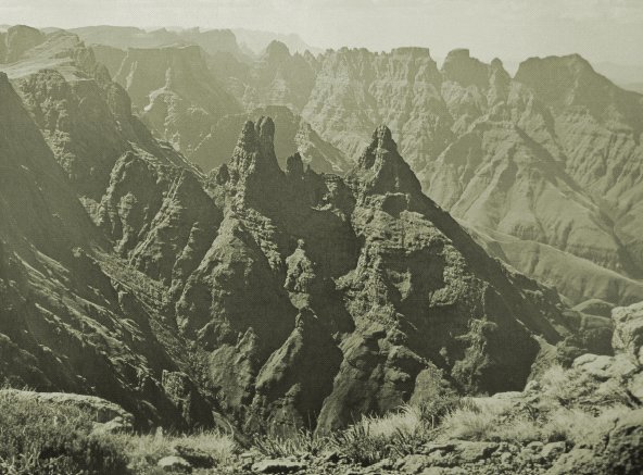
In South Africa; uKhahlamba Drakensberg Park; "Barrier
of Spears"
<<
PREV